What Is the Florida Land Use Map and How to Read It
Every land development project in Florida begins with one critical question: What is the property zoned for? The answer lies in the Florida Land Use Map—a planning tool that defines how land can be developed, from residential and commercial uses to industrial and conservation zones.
For developers, architects, and engineers, understanding how to read and interpret these maps is essential for identifying opportunities, avoiding conflicts, and ensuring code compliance from the start.
Why Land Use Maps Matter
Florida’s Future Land Use Maps (FLUMs) guide growth, shape infrastructure, and maintain a balance between urban expansion and environmental protection. Each county and municipality has its own map, adopted as part of its Comprehensive Plan, under the Florida Community Planning Act (Chapter 163, F.S.).
For developers, reviewing these maps early helps determine:
What type of project is permitted.
Whether rezoning or land use amendments are needed.
How density, infrastructure, and stormwater design requirements will apply.
For insights on local regulatory influence, read: The Role of County Engineers in Florida Land Development.
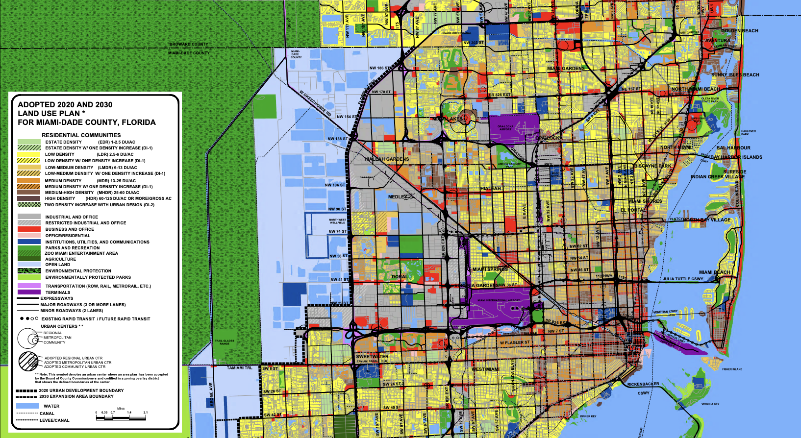
Key Elements of the Florida Land Use Map
| Element | Description |
|---|---|
| Land Use Categories | Designations such as Residential, Commercial, Industrial, Agricultural, or Conservation define permitted uses and density. |
| Color Coding | Maps use color to differentiate zones—for example, yellow for residential, red for commercial, and green for open space. |
| Overlay Districts | Special planning areas, such as flood zones or coastal management areas, impose additional design or permitting rules. |
| Zoning Consistency | All development must be consistent with both zoning and the adopted future land use category. |
| Amendment Process | Developers may request land use changes through local planning boards and public hearings. |
Working With Land Use and Zoning Departments
Before beginning design, developers and planning engineers should review the property’s parcel information using their county’s GIS portal—for example, the Miami-Dade County GIS Portal or Broward County Land Use Map Viewer.
Consulting with the county’s Planning and Zoning Department helps clarify whether proposed uses are allowed “by right” or if additional approvals (such as variances or conditional uses) are needed.
Understanding how these approvals interact with site engineering is crucial—see our related post: Tree Removal Permits in Florida: Municipal Requirements.
Common Challenges
Land use interpretation isn’t always straightforward. Developers frequently face issues such as:
Inconsistent Zoning and Land Use Categories: A parcel’s zoning may not match its designated future use.
Overlay Conflicts: Flood zones, coastal setbacks, or conservation areas can limit buildable area.
Public Review Delays: Amendments require planning board review, advertising, and public hearings.
A civil engineering company in Florida can help navigate these complexities, ensuring that stormwater, grading, and access designs comply with both zoning and environmental codes.
For more on managing multi-agency coordination, read: Building in Environmentally Sensitive Areas in Florida.
Conclusion
Florida’s Land Use Maps are more than planning visuals—they’re the foundation of every development decision. Understanding them ensures your project begins on solid regulatory ground, saving time and preventing costly redesigns.
Working with a qualified land development consultant simplifies this process by integrating zoning, engineering, and permitting expertise into one coordinated approach.
FAQs
-
Each Florida county publishes its Land Use Map on its planning department website or GIS portal.
-
Land use designates general purpose (residential, commercial, etc.), while zoning defines specific regulations like building height and setbacks.
-
Yes, but it requires a formal amendment process with public hearings and approval from local governing bodies.
-
Absolutely. Higher-intensity land uses often require more robust stormwater systems—see our post on How Local Drainage Districts Affect Site Development.
Partnering With Florida Experts for Development Success
At RSP Engineers, we help developers interpret land use maps, prepare due diligence reports, and design fully compliant site development plans. Our experience with Florida’s zoning and environmental regulations ensures a smooth transition from planning to construction—no surprises, no setbacks.