Understanding Overlay Zoning Districts in Florida
Florida’s land development regulations often go beyond traditional zoning. In many cities and counties, Overlay Zoning Districts add extra layers of rules on top of base zoning to address unique environmental, design, or community goals.
For engineers and developers, understanding these overlay districts is critical — they can significantly affect drainage, setbacks, building heights, and even architectural styles.
What Are Overlay Zoning Districts?
An Overlay Zoning District is a mapped area that imposes additional requirements over existing base zoning.
The intent is to address special conditions or planning objectives not covered by the general zoning code — such as flood protection, coastal preservation, or neighborhood character.
Each overlay district modifies or supplements the base zoning, often with more restrictive standards.
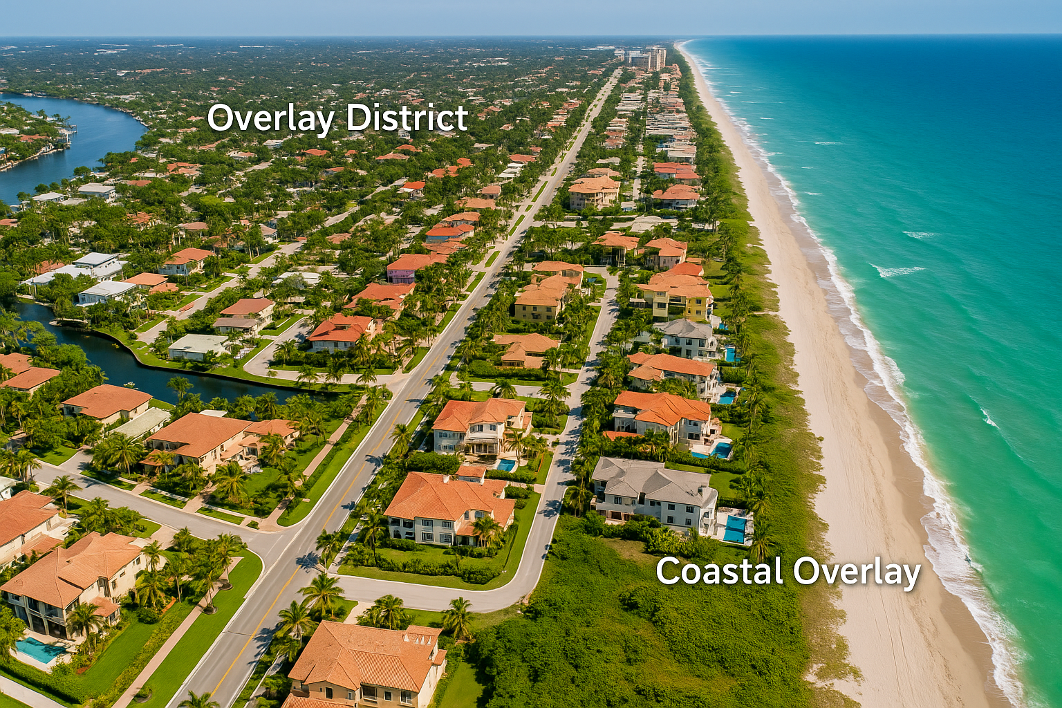
For example, a property zoned “C-1 Commercial” within a “Coastal Resilience Overlay” may have additional rules about elevation, materials, and drainage.
Common Types of Overlay Districts in Florida
| Overlay Type | Purpose | Key Engineering Considerations |
|---|---|---|
| Coastal Resilience Overlay | Protect structures and infrastructure from storm surge and sea level rise. | Higher minimum elevations, flood-resistant materials, stricter stormwater controls. |
| Historic Preservation Overlay | Preserve architectural character of designated areas. | Restricted exterior alterations, material selection, and site grading limits. |
| Environmental Protection Overlay | Safeguard wetlands, habitats, or aquifer recharge zones. | Buffers, low-impact design (LID), and reduced impervious coverage. |
| Transit-Oriented Development (TOD) Overlay | Encourage compact, walkable, and transit-connected communities. | Reduced parking, improved pedestrian connectivity, and drainage integration. |
| Airport Compatibility Overlay | Regulate building heights and noise mitigation near airports. | FAA height restrictions, stormwater pond placement, and lighting controls. |
How Overlay Districts Affect Site Design
Overlay districts can influence multiple civil design elements, including:
Elevation & Drainage: Additional freeboard above BFE, stricter stormwater criteria.
Impervious Area Limits: Reduced coverage to enhance infiltration.
Utility Placement: Restrictions near protected environmental features.
Traffic & Access: Alignment with multimodal or transit-oriented standards.
Erosion & Sediment Control: Stricter compliance for sensitive areas.
For flood-related overlays, see:
FEMA BFE Requirements in Florida Site Plans.
Examples of Florida Overlay Districts
Across Florida, many counties and municipalities apply overlay districts to manage development in sensitive or high-growth areas.
Here are a few examples:
Miami-Dade County – Coastal High Hazard Area Overlay: applies stricter flood elevation and stormwater requirements along coastal zones.
Broward County – Urban Design Overlay: enhances walkability and pedestrian connectivity in dense commercial corridors.
Palm Beach County – Wellfield and Wetlands Protection Overlay: limits impervious surfaces and manages drainage near groundwater recharge zones.
City of Orlando – Downtown Design Overlay: ensures architectural consistency and streetscape quality in the urban core.
City of Tampa – Historic Ybor Overlay: preserves architectural heritage and streetscape character.
Each of these overlays introduces specialized engineering or design criteria that go beyond the base zoning district, influencing how civil engineers design grading, drainage, and utility systems.
You can explore overlay maps through the Florida Geographic Data Library (FGDL) or local GIS mapping portals such as:
Miami-Dade GIS Portal.
How Engineers Navigate Overlay Reviews
The overlay district review is typically part of the site plan or DRC process. Engineers must:
Identify if the parcel lies within any overlay zones using county GIS.
Review overlay-specific design manuals.
Incorporate required elements in the drainage, grading, and utility plans.
Coordinate with planning and zoning staff for compliance verification.
Include overlay references on the title sheet (e.g., “Subject to Coastal Resilience Overlay”).
To learn more about these submittals, see:
Preparing for a Development Review Committee (DRC) Meeting.
Common Challenges with Overlay Districts
Conflicts between overlay and base zoning standards.
Inconsistent map interpretations between county and city systems.
Drainage design limitations due to environmental buffers.
Additional permit layers (FDEP, SFWMD, or Army Corps).
Extended review timelines for projects in sensitive overlays.
Proper coordination early in the design phase can prevent major redesigns or delays.
Conclusion
Overlay zoning districts are powerful tools for guiding responsible growth and environmental protection in Florida.
For engineers, understanding these layers ensures that site plans meet all regulatory expectations and align with long-term community goals.
At RSP Engineers, we integrate overlay district criteria into every project — ensuring code compliance, efficient permitting, and sustainable design.
FAQs
-
Check your local GIS portal or comprehensive plan map.
-
Yes — the overlay requirements typically take precedence when more restrictive.
-
Often, yes. Many require additional retention or water quality measures.
-
City or county planning departments, often during the DRC or site plan review stage.
Partnering With Florida Developers for Zoning Compliance
At RSP Engineers, we help developers navigate Florida’s complex zoning and overlay systems — ensuring every project meets local, regional, and environmental standards.