
What Is a Conceptual Site Plan? A Florida Developer’s Guide
Learn what a conceptual site plan is and why it’s a critical first step in Florida land development. Discover its role in zoning, permitting, and feasibility analysis.
The Core Purpose: From Vision to Viability Assessment
The primary function of a conceptual site plan is to serve as a comprehensive feasibility study. It bridges the gap between a developer’s initial idea and the complex realities of land development. This plan allows a Civil Engineer near me to conduct an initial but critical analysis to determine if the project’s goals—be it a 300-unit apartment complex, a retail center, or a single-family subdivision—can be realistically achieved on the subject property. It’s a low-cost, high-value exercise in due diligence that answers fundamental questions before the financial commitment escalates. This process involves a thorough evaluation of major site constraints and opportunities. We analyze the property’s size, shape, topography, and any existing environmental features like wetlands or protected trees. Simultaneously, we perform a detailed review of the local jurisdiction’s regulations to ensure preliminary zoning compliance. The conceptual layout helps visualize potential conflicts, such as a building footprint encroaching on a required setback or a parking lot that doesn’t meet the minimum stall count. This early-stage analysis is crucial for making informed go/no-go decisions.
Key Components of a Conceptual Site Plan
Conceptual vs. Preliminary vs. Final Site Plan Comparison
| Element | Conceptual Site Plan | Preliminary Site Plan | Final Site Plan (Construction Documents) |
|---|---|---|---|
| Level of Detail | High-level, schematic layout. Focus on massing, circulation, and land use allocation. | More refined layout with preliminary dimensions, grades, and utility alignments. | Fully detailed and dimensioned plans with complete specifications for construction. |
| Engineering Calculations | Approximate calculations for feasibility (e.g., parking counts, rough stormwater volume). | Initial engineering calculations for grading, drainage, and utilities. A preliminary stormwater report is often included. | Final, signed-and-sealed calculations for all site elements, including stormwater, utilities, and paving. |
| Utility Design | Identifies general corridors and connection points. Confirms service availability. | Shows preliminary pipe sizes, alignments, and invert elevations. Major structures are located. | Complete design of all utility systems, including profiles, structure details, and material specifications. |
| Stormwater Design | Blocks out an approximate pond footprint based on impervious area estimates. | Includes preliminary pond design, grading, and outfall structure location. Supported by a drainage report. | Complete, detailed drainage design with cross-sections, control structure details, and full hydraulic modeling. |
| Permitting Status | Pre-permitting tool for due diligence and agency pre-application meetings. Not for formal submittal. | Used for initial permit submittals to planning/zoning boards and sometimes initial agency review. | The official set of drawings submitted for all required construction permits (site, building, environmental). |
| Cost to Produce | Lowest cost. A small fraction of the total design fee, focused on risk mitigation. | Moderate cost. Involves more detailed engineering and survey data. | Highest cost. Represents the full scope of the civil engineering design effort. |
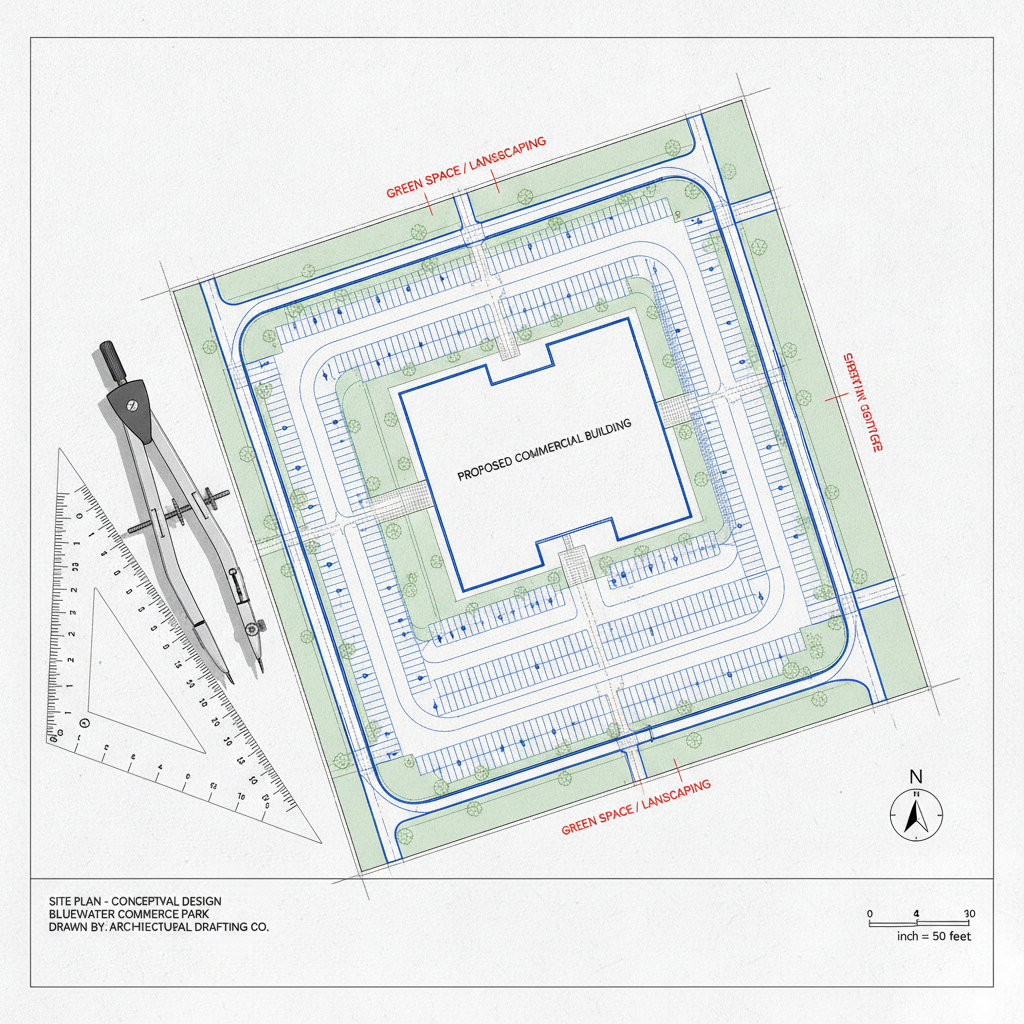
While less detailed than later engineering drawings, a robust conceptual site plan contains specific, critical information. It is a carefully curated document designed to provide a holistic overview of the proposed project. The goal is to include enough detail to facilitate meaningful discussions with stakeholders and regulatory agencies without getting bogged down in the minutiae of final site plan design. A well-prepared plan will clearly delineate the spatial relationships between all major project elements. Key components typically illustrated on the plan include: Building Footprints: Shows the proposed size, shape, and location of all structures. Parking Layout: Depicts parking stalls, drive aisles, and loading zones to verify capacity and flow. Access and Circulation: Identifies proposed entrances and exits, internal roadways, and pedestrian pathways, considering both on-site and off-site traffic impacts. Preliminary Stormwater Management Areas: Blocks out approximate locations and sizes for retention or detention ponds, which is a critical consideration in Florida civil engineering. Utility Corridors: Indicates general paths for major utilities like water, sewer, and storm drains. Open Space and Landscaping: Shows areas designated for greenspace, buffers, and recreational amenities as required by zoning compliance. Key Site Features: Notes the location of significant existing elements like wetlands, easements, and mature trees that will influence the site development.
Zoning and Land Use Compliance Analysis
In Florida, navigating the intricate web of local zoning codes and comprehensive plans is one of the most significant challenges in land development. A conceptual site plan is the primary tool for this analysis. Our engineers meticulously review the applicable land use designation and zoning district regulations to ensure the proposed project aligns with municipal requirements. This step is non-negotiable and prevents costly redesigns or fatal permit denials down the road. This analysis verifies compliance with numerous quantitative and qualitative standards. We check for adherence to setback requirements from property lines, wetlands, and roadways. We calculate and confirm that the proposed lot coverage, building height, and floor area ratio (FAR) are within permissible limits. Furthermore, we ensure the plan meets density or intensity thresholds, parking ratios, and open space requirements. Identifying a need for a variance, rezoning, or special exception at this early stage allows the development team to build a strategy and timeline for securing the necessary development entitlements.
Preliminary Utility and Infrastructure Assessment
A project cannot succeed without adequate access to essential services. The conceptual site plan plays a vital role in the preliminary utility coordination and infrastructure assessment. It provides a framework for identifying the nearest connection points for potable water, sanitary sewer, electricity, and communications. This initial investigation helps determine the feasibility of servicing the site and uncovers potentially significant off-site improvement costs. For example, the plan may reveal that a sanitary sewer main is hundreds of feet away, requiring a costly extension or the installation of a lift station. Our team uses the conceptual layout to evaluate existing infrastructure capacity with local utility providers. We initiate early conversations to confirm if the municipal systems can support the additional demand generated by the project. This process also helps in easement identification, revealing if new easements must be acquired from adjacent properties to run utility lines. Addressing these major infrastructure challenges at the conceptual stage is critical for developing an accurate project budget and timeline, preventing major surprises during the formal permitting process.
Evaluating Stormwater Management and Drainage Strategies
Stormwater management is arguably one of the most critical aspects of civil engineering in Florida. Due to the state’s flat topography, high water table, and intense rainfall events, regulatory agencies like the Water Management Districts (WMDs) have stringent requirements. The conceptual site plan is the first line of defense in ensuring a project can comply with these rules. It forces the design team to allocate a realistic amount of land for stormwater management facilities, such as wet retention or dry detention ponds. During this phase, we perform high-level calculations based on the proposed impervious surface area (roofs, pavement, etc.) to estimate the required pond volume and footprint. This ensures that the most valuable land isn’t over-allocated to buildings and parking, only to discover later that there is insufficient space for required drainage design. This proactive approach prevents the need for costly and inefficient underground storage systems and confirms the project’s fundamental viability from a stormwater perspective before significant design fees are incurred.
The Role in Early Agency and Stakeholder Discussions
Beyond internal due diligence, the conceptual site plan is an invaluable communication tool for external stakeholders. It is often the centerpiece of pre-application meetings with local planning and zoning departments. Presenting a clear, well-thought-out conceptual plan allows for productive dialogue with agency staff, helping to identify potential concerns and regulatory hurdles early. This collaborative approach can streamline the formal agency review process later on. This document is also essential for securing financing and gaining buy-in from investors. It visually translates the project’s business plan into a tangible layout, demonstrating that the development team has done its homework. For projects that may face community opposition, the conceptual plan can be used in public workshops to explain the project’s vision and gather feedback. This level of stakeholder engagement, facilitated by a professional plan, builds credibility and can smooth the path toward final approval of permit submittals.
How RSP Engineers Develops a Conceptual Site Plan
At RSP Engineers, our approach to conceptual design is a systematic process focused on maximizing value and minimizing risk for our clients. We treat it as the strategic foundation for the entire project. Our process begins with a deep dive into the client’s vision and programmatic needs, ensuring we understand the project’s financial and operational goals. This is followed by comprehensive due diligence, where we gather and analyze all relevant data, including zoning codes, utility maps, surveys, and environmental reports. Our team of experienced Civil Engineers then engages in an iterative design process, sketching multiple layouts to optimize the use of space while respecting the site’s natural and regulatory constraints. We use this phase to map out critical elements, test different circulation patterns, and strategically locate major infrastructure like stormwater ponds and utility connections. The final deliverable is not just a drawing, but a complete conceptual package that includes the site plan, a summary of our findings, and a clear, actionable feasibility report outlining the project’s strengths, weaknesses, and recommended next steps.
Common Pitfalls and Challenges in Conceptual Planning
While a conceptual site plan is a powerful tool, its effectiveness depends on the thoroughness of the underlying analysis. A common pitfall is underestimating the land required for effective stormwater management, especially under Florida’s strict regulations. Another frequent issue is overlooking existing easements or deed restrictions that can severely limit the usable area of a property. Misinterpreting nuanced language in a zoning code can also lead to a flawed layout that requires a complete redesign. Other challenges include failing to account for off-site improvements, such as required turn lanes or utility upgrades, which can add significant costs. Ignoring potential environmental constraints like wetlands or protected species habitat can cause major delays and trigger extensive permitting hurdles. A successful conceptual planning phase requires a proactive, detail-oriented approach from an experienced civil engineering firm near me to identify and address these design constraints before they derail a project.
Start Your Florida Land Development Project with Confidence
A successful project begins long before the first shovel hits the ground. It begins with a strategic, data-driven conceptual site plan. This critical first step ensures your vision is viable, your budget is realistic, and your path to permitting is clear. The team at RSP Engineers specializes in providing the rigorous upfront analysis needed to navigate Florida’s complex development landscape. We are one of the top Civil Engineering firms in the state. Don’t leave your project’s success to chance. Let our experts help you with comprehensive site development feasibility, detailed zoning compliance reviews, and proactive utility coordination. Contact RSP Engineers today to discuss how our conceptual design services can provide the clarity and confidence you need to move your project forward.
Conclusion: The Foundation of Successful Site Development
Ultimately, a conceptual site plan is an investment in certainty. It is the most effective tool for mitigating risk in the early stages of a project, providing a clear and realistic assessment of what can be achieved on a piece of property. By addressing critical issues related to zoning, utilities, drainage, and access upfront, this process lays a solid foundation for all subsequent design and engineering efforts. For developers in Florida, embracing this strategic step is essential for navigating the complexities of the market and ensuring a smooth transition from vision to a successfully completed project. It is the cornerstone of sound civil engineering and intelligent land development.
FAQs
-
No, a conceptual site plan is a pre-permitting tool and is not typically submitted for a formal construction permit. It is used for due diligence, feasibility analysis, and preliminary discussions with regulatory agencies. The information developed during this phase provides the foundation for the detailed engineering drawings required for official permit submittals.
-
The cost varies depending on the project’s size and complexity, but it represents a small fraction of the total design and engineering fees. The return on investment is extremely high, as it can prevent a developer from investing heavily in a project with a “fatal flaw” related to zoning compliance or site constraints.
-
For a typical project, a conceptual site plan and feasibility report can be completed in one to three weeks. The timeline depends on the availability of existing information, such as a current boundary and topographical survey, and the responsiveness of local agencies when verifying utility and zoning information.