
Selecting Boring Locations for Data Center Campuses
Learn how to strategically select soil boring locations for data center campuses. Our guide covers building pads, substations, stormwater facilities, and utility corridors.
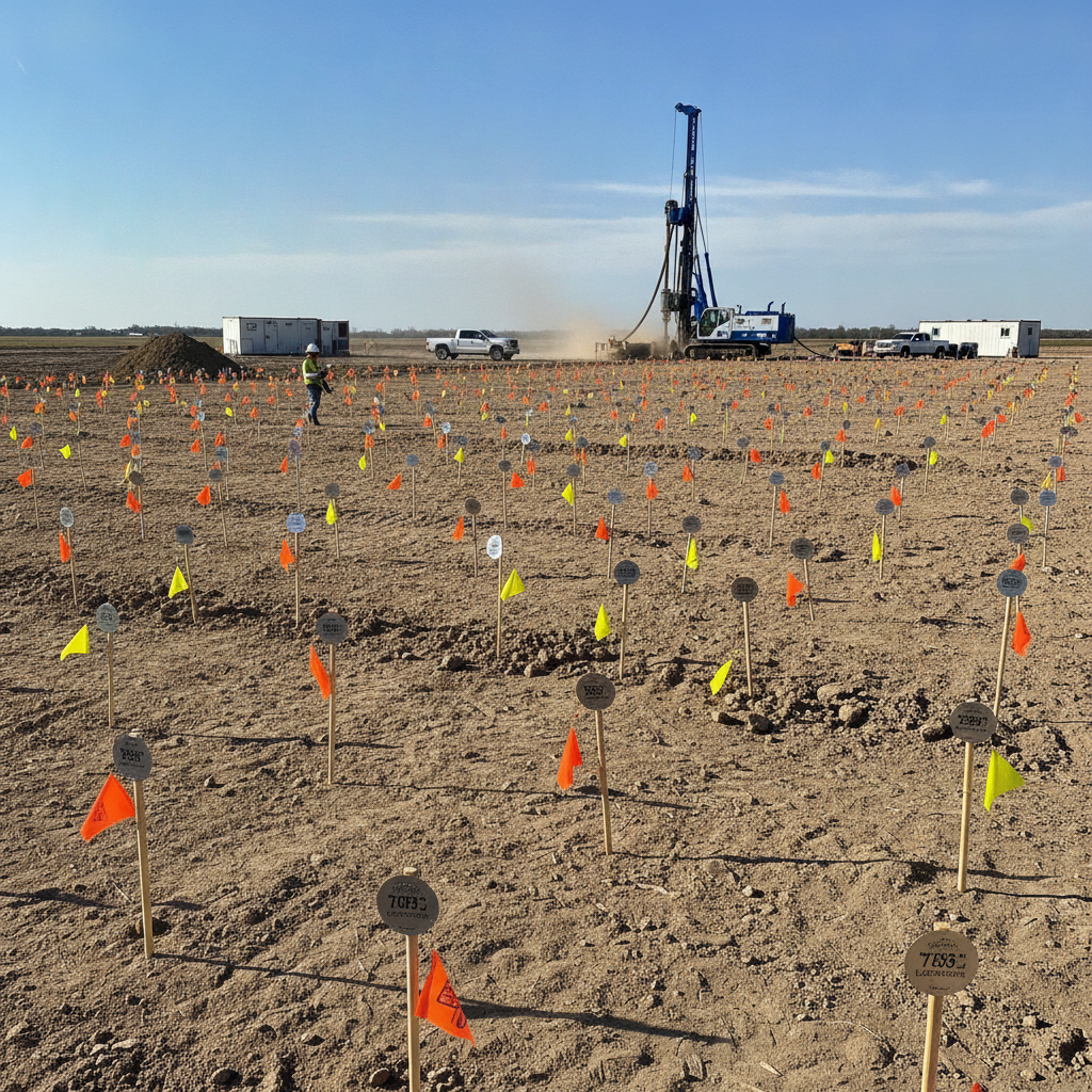
The Strategic Importance of Geotechnical Investigation for Mission-Critical Facilities
Data centers have zero tolerance for structural movement. Even minor differential settlement can damage sensitive equipment, disrupt fiber optic connections, and compromise the integrity of the facility. A thorough geotechnical investigation is the primary risk mitigation tool for foundation design. It provides critical data on soil bearing capacity, the presence of problematic soil types (such as expansive clays or liquefiable sands), groundwater levels, and the depth to bedrock or other competent strata. The goal is to develop a detailed subsurface profile that informs every aspect of the site development process. This includes selecting the appropriate foundation system (e.g., shallow spread footings vs. deep foundations like piles or caissons), designing stable pavement sections for heavy vehicle traffic, and engineering effective stormwater management systems. Without this data, engineers are designing in the dark, and the project owner is exposed to significant unforeseen risks and costs.
Establishing Baseline Coverage Across the Campus
Boring Location and Spacing Guidelines for Data Center Components
| Component Area | Primary Geotechnical Concern | Typical Boring Spacing / Depth |
|---|---|---|
| Data Hall / Building Pad | Settlement, bearing capacity, soil uniformity | 50-75 ft spacing; one at each corner and major column. Depth determined by foundation influence zone. |
| Electrical Substation / Equipment Yard | High bearing pressure, vibration sensitivity, settlement | One at each corner and center of major equipment pads. Depth to confirm stable bearing stratum. |
| Stormwater Retention/Detention Ponds | Infiltration rates, seasonal high water table, slope stability | 2-3 borings within pond footprint. Depth to below pond bottom to assess groundwater and soil permeability. |
| Pavement and Roadways | Subgrade stability, pavement section design (CBR values) | 150-300 ft spacing along centerlines. Depth of 5-10 ft below proposed subgrade. |
| Underground Utility Corridors | Depth to rock, groundwater, trench stability | 200-400 ft spacing along major trunk lines. Depth to 5 ft below proposed invert elevation. |
| Perimeter Security Walls / Fencing | Lateral stability, frost heave, bearing capacity for footings | 200-500 ft spacing along alignment. Shallow borings sufficient for typical footing design. |
The first phase of a subsurface investigation typically involves establishing a baseline understanding of the entire site. This is often achieved by laying out borings in a grid pattern across the property. For large, undeveloped tracts, a spacing of 150 to 200 feet may be sufficient to identify major geological formations, map general soil strata, and detect significant changes in subsurface conditions. This initial phase helps the civil engineering team identify broad areas of concern that may require more detailed investigation later. This baseline approach provides a foundational dataset for preliminary site planning and grading design. Initial boring layout and spacing recommendations often follow established industry practices, but specific requirements can vary by jurisdiction, and the project’s Geotechnical engineer must confirm all applicable standards with the local, state, and regional authorities. This early characterization is crucial for identifying potential fatal flaws before significant design capital is expended.
Targeted Boring Plans for High-Load Structures
Once the overall site is characterized, the focus shifts to areas planned for significant structural loads. The boring plan must be intensified in these locations to provide the high-resolution data needed for detailed foundation design. A generic grid is no longer sufficient; borings must be placed strategically based on the proposed site plan design. Data Hall and Building Pads For the main data hall and ancillary buildings, boring spacing is typically tightened to 50 to 75 feet, with at least one boring at each corner of the proposed building and additional borings at the locations of heavily loaded columns or interior load-bearing walls. The depth of these borings is critical; they must extend well below the foundation influence zone to accurately predict long-term settlement. This ensures the foundation design accounts for all underlying soil layers that will be affected by the structure’s immense weight. Equipment Yards and Substation Areas Outdoor equipment yards and electrical substations support extremely heavy and vibration-sensitive equipment, such as transformers, switchgear, and backup generators. The boring plan in these areas must verify adequate soil bearing capacity for their concrete pads and foundations. Borings are strategically placed at the corners and center of each major equipment pad to confirm soil uniformity and prevent differential settlement that could damage the machinery or its electrical connections.
Characterizing Stormwater and Utility Infrastructure Corridors
A comprehensive geotechnical investigation extends beyond building footprints. The performance of critical site infrastructure, including stormwater facilities and utilities, is also dependent on subsurface conditions. Neglecting these areas can lead to drainage failures, utility line breaks, and costly repairs. Borings within the footprint of proposed stormwater management ponds are essential for two reasons. First, they determine the soil’s infiltration characteristics, which is critical for the design of retention or infiltration-based systems. Second, they identify the seasonal high groundwater table, which dictates the effective storage volume of the pond and can impact slope stability. For underground utilities, borings along the primary corridors for power, water, and fiber can identify the depth to rock, which significantly impacts excavation costs, or locate unstable soils that may require special trenching and backfill procedures to ensure long-term utility coordination and protection.
Integrating Site Constraints and Evolving Designs
A boring plan is a living document that must adapt to real-world conditions. One of the first and most critical steps before any drilling is comprehensive utility clearance. This involves contacting the state’s one-call utility notification center (e.g., 811) and, often, hiring a private utility locator to clear each proposed boring location. Hitting an underground utility can be dangerous and expensive, and it is an entirely avoidable risk. Site access is another major consideration. Steep slopes, dense vegetation, wetlands, or existing structures can prevent a drill rig from reaching an ideal location. The Geotechnical engineer must work with the survey and civil engineering team to find accessible alternative locations that still meet the investigation’s objectives. Furthermore, as the site plan design evolves, the boring plan must be updated. If a building footprint shifts or a new stormwater pond is added, supplementary borings are required to provide data for the revised locations, ensuring no part of the design is based on untested assumptions.
Our Process: A Phased Approach to Geotechnical Site Characterization
At RSP Engineers, we approach every geotechnical investigation systematically. Our process begins with a thorough desktop study, reviewing publicly available geological maps, soil surveys, and historical aerial imagery. We then develop a preliminary boring plan tailored to the project’s specific scope and known site features. Our field operations are overseen by an experienced Geotechnical engineer who can adapt the plan in real-time based on conditions encountered during drilling. Soil samples are carefully collected and transported to a certified laboratory for testing to determine their engineering properties. This data is then analyzed by a licensed Professional Engineer who prepares a comprehensive Geotechnical soil report. This report provides not just raw data, but actionable recommendations for foundation design, earthwork specifications, and pavement sections, forming a critical component of the overall civil engineering design package.
Common Issues Encountered During Subsurface Investigations
Even with careful planning, subsurface investigations can reveal challenging conditions. Encountering shallow bedrock can dramatically increase excavation and utility installation costs. A high water table may necessitate dewatering systems during construction and influence foundation or basement design. The discovery of undocumented or unsuitable fill materials from previous site use can require costly removal and replacement. Other potential issues include identifying soft, compressible clays that lead to settlement problems or encountering karst terrain features that may require specialized foundation solutions. A well-executed geotechnical investigation is designed to identify these issues early in the design process, allowing the project team to address them proactively rather than reacting to them as expensive construction-phase surprises. Frequently Asked Questions How deep do soil borings for a data center need to be? The depth depends on the structure. For a heavily loaded data hall, borings must extend deep enough to analyze stresses on all underlying soil layers, often 50 to 100 feet or more, or until competent bedrock is reached. For shallower structures like pavements or stormwater ponds, a soil boring test might only need to be 10 to 20 feet deep. What happens if you find unsuitable soil during the investigation? If unsuitable soils like soft clays, loose sands, or undocumented fill are discovered, the Geotechnical soil report will provide recommendations. Options may include over-excavation and replacement with engineered fill, chemical soil stabilization, or the use of a deep foundation system (like piles) to transfer loads to a deeper, more competent soil layer. Can the boring plan be adjusted once drilling starts? Absolutely. A key role of the field engineer or geologist is to observe the drilling and soil conditions. If unexpected conditions are found, or if a boring refuses on rock much shallower than anticipated, the Geotechnical engineer may add, move, or deepen borings to better define the issue. Is a geotechnical investigation required for permitting? In most cases, yes. The authority having jurisdiction typically requires a Geotechnical soil report stamped by a licensed Professional Engineer as part of the building permit submittal package. This ensures the foundation design is based on actual site conditions and complies with building code requirements for safety and stability. How does groundwater affect the boring plan and foundation design? Groundwater levels are a critical piece of data. Borings are used to establish the static water level and can be used to install piezometers for long-term monitoring. High groundwater can affect soil bearing capacity, require permanent sub-drain systems, and increase construction costs due to dewatering requirements. What is the difference between a soil boring test and a percolation test? A soil boring test is part of a broader geotechnical investigation to determine the engineering properties of soil for structural support. A percolation test is a specific type of test, often done in a separate, shallow excavation, designed exclusively to measure the rate at which water drains into the soil, which is used for designing septic systems or stormwater infiltration basins.
Partner with RSP Engineers for Your Next Mission-Critical Project
A successful data center project depends on a precise and thorough understanding of your site’s subsurface conditions. The team at RSP Engineers provides expert civil engineering and site development services, including the critical coordination of geotechnical investigations. We help clients develop strategic boring plans, interpret complex geotechnical soil report data, and integrate the findings into a cohesive and cost-effective design. From initial due diligence to final permitting, we are your trusted partner in building resilient mission-critical infrastructure.
Conclusion
Selecting soil boring locations for a data center campus is a strategic exercise in risk management. It requires a multi-faceted approach that combines a broad baseline grid with targeted, high-density investigations at all critical infrastructure locations. A properly planned and executed geotechnical investigation is not an expense; it is a fundamental investment in the long-term stability, security, and operational success of the facility. By partnering with experienced civil engineering professionals, developers can ensure their foundation design is built on a solid base of data and expertise.
FAQs
-
Selecting Boring Locations for Data Center Campuses requires careful planning, qualified engineering, and compliance with the applicable codes and permits.
-
Getting Selecting Boring Locations for Data Center Campuses right protects safety, supports regulatory compliance, and avoids costly redesigns or delays.
-
RSP Engineers provides licensed expertise and end-to-end support for Selecting Boring Locations for Data Center Campuses, from early planning through permitting.