
Seasonal High-Water Table Evaluation for Data Center Sites
A precise Seasonal High-Water Table (SHWT) evaluation is critical for data center site development. Learn the methods, from soil indicators to monitoring, and the impacts on foundations, stormwater, a
Why a Single Water Table Reading is Insufficient
A common and dangerous mistake in preliminary site assessments is relying on a single groundwater reading from a soil boring test. The water level observed on one particular day, especially during a dry season or drought period, is merely a snapshot in time. It does not represent the recurring, elevated conditions that building foundations, underground utilities, and stormwater infiltration systems will be subjected to over the life of the facility. Groundwater levels are dynamic, fluctuating in response to seasonal rainfall, major storm events, and even long-term climatic cycles. Basing a multi-million dollar data center design on this single data point invites unacceptable risk. A comprehensive civil engineering analysis is required to establish a true SHWT. This involves a multi-faceted investigation that looks beyond the current water level to find physical evidence and historical data that tell the complete story of the site’s hydrology. This rigorous approach is essential for accurate drainage design and for securing regulatory approvals from review agencies.
Identifying Redoximorphic Features in Soil Profiles
Methods for Estimating Seasonal High-Water Table
| Method | Description | Pros | Cons / Limitations |
|---|---|---|---|
| Direct Observation (Single Boring) | Measuring the water level in a freshly drilled soil boring. | Quick, low initial cost. | Highly unreliable; only a snapshot in time and can be misleading. |
| Redoximorphic Feature Analysis | Visual inspection of soil profiles in test pits by a Geotechnical engineer for mottling and gleying. | Excellent indicator of long-term historical high water levels. Widely accepted by regulators. | Requires expert interpretation; may be less clear in disturbed or fill soils. |
| Piezometer / Monitoring Well | Installing wells to collect direct water level data over weeks or months. | Provides precise, site-specific hydrographic data. Excellent for calibrating models. | Higher cost and requires time; data represents only the monitoring period. |
| Regional Hydrologic Modeling | Using existing regional groundwater models and rainfall data to predict site conditions. | Good for initial feasibility and understanding regional trends. | Not site-specific enough for final design without field verification. |
| Combined Method (Best Practice) | Integrating redoximorphic analysis, well monitoring, and regional data correlation. | Most accurate, reliable, and defensible method for mission-critical projects. | Requires the most expertise, time, and budget, but minimizes long-term risk. |
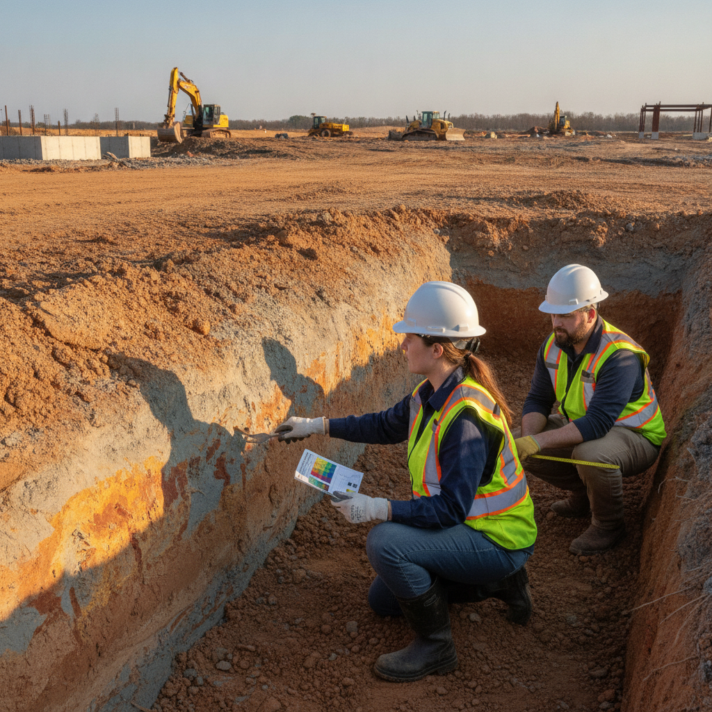
One of the most reliable methods for determining the SHWT is through direct observation of the soil profile, a key component of any thorough Geotechnical Engineering study. A qualified Geotechnical engineer or soil scientist examines soil excavated from test pits to identify redoximorphic features. These are distinct color patterns in the soil, such as mottling (spots or blotches of different colors) and gleying (grayish or bluish colors), that form due to prolonged periods of saturation and oxygen deprivation. These features serve as a long-term physical record of where the water table has historically fluctuated, effectively staining the soil. They provide a much more reliable indicator of the true SHWT than a one-time water level measurement. The presence, depth, and characteristics of these features are meticulously documented in the geotechnical soil report, forming a critical piece of evidence for the final SHWT determination and subsequent site plan design.
Integrating Monitoring Well Data and Regional Records
For complex sites or where required by regulators, direct monitoring provides invaluable data. This involves installing piezometers or monitoring wells to collect direct water level measurements over an extended period, often spanning a full wet season. This data provides a precise record of how the water table responds to rainfall events. To be truly effective, this site-specific data must be correlated with long-term regional hydrologic records, such as rainfall data and data from nearby government-operated monitoring wells. This statistical correlation allows the project team to place the site’s monitored behavior within a broader historical context, ensuring the determined SHWT accounts for long-term climate variability. This robust, data-driven approach creates a highly defensible basis for design and is crucial for navigating the agency review process. Permitting requirements for monitoring duration and data analysis vary by jurisdiction, and every project team should confirm the applicable standards with the local, state, regional, and federal authorities that hold review authority over the site. This step is fundamental to successful permit submittals.
Table: Methods for Estimating Seasonal High-Water Table
Method Description Pros Cons / Limitations Direct Observation (Single Boring) Measuring the water level in a freshly drilled soil boring. Quick, low initial cost. Highly unreliable; only a snapshot in time and can be misleading. Redoximorphic Feature Analysis Visual inspection of soil profiles in test pits by a Geotechnical engineer for mottling and gleying. Excellent indicator of long-term historical high water levels. Widely accepted by regulators. Requires expert interpretation; may be less clear in disturbed or fill soils. Piezometer / Monitoring Well Installing wells to collect direct water level data over weeks or months. Provides precise, site-specific hydrographic data. Excellent for calibrating models. Higher cost and requires time; data represents only the monitoring period. Regional Hydrologic Modeling Using existing regional groundwater models and rainfall data to predict site conditions. Good for initial feasibility and understanding regional trends. Not site-specific enough for final design without field verification. Combined Method (Best Practice) Integrating redoximorphic analysis, well monitoring, and regional data correlation. Most accurate, reliable, and defensible method for mission-critical projects. Requires the most expertise, time, and budget, but minimizes long-term risk.
Implications for Stormwater Management and Infiltration Systems
The established SHWT has direct and significant consequences for stormwater management design. Most environmental regulations require a minimum vertical separation—typically several feet—between the bottom of an infiltration-based stormwater practice (like a retention pond, infiltration trench, or permeable pavement system) and the SHWT. This separation is necessary to ensure proper water treatment and prevent groundwater contamination. If the SHWT is too high, infiltration-based designs may be deemed non-compliant or completely infeasible. This forces the civil engineering team to pivot to alternative designs, such as lined detention ponds that do not infiltrate or complex underdrain systems, which can increase construction costs and the project’s overall land footprint. An accurate SHWT determination early in the design process is therefore critical for developing a viable and permittable drainage design.
Impact on Foundation Design and Building Pad Elevations
A high SHWT poses a significant threat to building foundations. Prolonged soil saturation can reduce soil bearing capacity, leading to potential settlement issues. It also introduces the risk of hydrostatic pressure acting on foundation walls and floor slabs, which can cause structural damage and water intrusion. The Geotechnical Engineering investigation must carefully consider these risks. To mitigate these issues, a high water table may necessitate costly design changes. Options include implementing deep foundation systems (like piles), installing extensive subsurface drainage and waterproofing systems, or raising the entire building pad elevation with engineered fill. Each of these solutions adds substantial cost and complexity to the site development process, underscoring the need for an early and accurate SHWT assessment to inform project budgeting and scheduling.
Challenges for Underground Utility and Trench Installation
The impact of a high SHWT extends below the building pad to all underground infrastructure. Excavating trenches for utilities like water, sewer, and electrical conduits becomes significantly more challenging in saturated soils. Trench walls can become unstable, requiring shoring and creating safety hazards. Persistent groundwater infiltration into trenches necessitates continuous dewatering operations, which can be costly and may require separate permits. Furthermore, buoyant forces from groundwater can cause empty conduits or lightweight utility structures to “float” before they are properly backfilled and secured. Proper utility coordination and construction sequencing are paramount. The design may need to incorporate trench underdrains, specialized backfill material, and concrete encasement to ensure the long-term stability and integrity of critical underground lifelines.
Our Process: A Multi-Faceted Approach to SHWT Determination
At RSP Engineers, we recognize that a reliable SHWT is a non-negotiable input for data center design. Our process begins with a thorough desktop analysis of public soil surveys, topographic data, and regional hydrogeologic information. This is followed by a comprehensive field investigation program, executed in close collaboration with a qualified Geotechnical engineer. We utilize a combination of deep soil borings and open test pits to allow for direct visual inspection of soil profiles to identify redoximorphic indicators. Where site complexity or regulatory requirements demand it, we manage the installation and data collection from piezometers to develop a site-specific hydrograph. By integrating all these data sources, we establish a conservative and defensible SHWT elevation. This rigorous approach ensures our site plan design is resilient, compliant, and protects the owner’s investment by mitigating unforeseen groundwater-related risks during construction and operation.
Common Issues and Missteps in SHWT Assessment
Even experienced teams can make critical errors in SHWT evaluation. Some of the most common missteps we help clients avoid include: Over-reliance on Dry Season Data: Mistaking a single, low water level reading during a dry period for the true SHWT. Misinterpreting Soil Indicators: Confusing natural soil parent material coloration with true redoximorphic features, leading to an inaccurate assessment. Ignoring Site Alterations: Failing to consider how past or future mass grading and compaction can alter local groundwater flow and perched water conditions. Insufficient Documentation: Providing a poor or incomplete justification for the selected SHWT elevation, leading to lengthy delays during agency review and permitting.
Contact RSP Engineers for Your Mission-Critical Site Assessment
If you’re searching for a ‘Civil engineering firm near me’ with nationwide experience in mission-critical facilities, your search ends here. An accurate SHWT evaluation is the foundation of successful data center site development. The team at RSP Engineers provides the comprehensive analysis needed to navigate complex site challenges. We manage the entire process, from initial feasibility studies and Geotechnical Engineering coordination to final permitting and construction administration. Partner with us to ensure your project is built on a foundation of certainty and data-driven design.
Conclusion: Building on a Foundation of Certainty
The Seasonal High-Water Table is more than just a line on a drawing; it is a fundamental design constraint that dictates the feasibility, cost, and resilience of a data center project. A proactive, multi-faceted investigation that combines soil science, direct monitoring, and historical data analysis is the only way to mitigate the substantial risks posed by groundwater. Investing in a proper SHWT assessment is an investment in project certainty, protecting against costly surprises during construction and ensuring the long-term operational integrity of your mission-critical facility. This is a core discipline of professional land development and civil engineering.
FAQs
-
The water table is the groundwater level at any given moment. The Seasonal High-Water Table (SHWT) is the highest level that the water table is expected to reach on a recurring basis during the wettest part of the year, based on physical soil evidence and long-term data. Civil engineering design must be based on the SHWT, not a single water table reading.
-
The required monitoring duration can vary by jurisdiction. Some agencies may require data collection through a full wet season. However, a shorter monitoring period can often be statistically correlated with long-term rainfall data to develop a defensible SHWT, a key part of the geotechnical soil report.
-
Yes, permanent underdrain systems can be designed to locally lower and control the water table around critical infrastructure. However, these systems add significant cost and long-term maintenance obligations. They also may require extensive permitting, as the discharged water must be managed appropriately.