
Data Center Soil Borings: What Developers Need to Know
A guide for data center developers on soil borings, SPT N-values, and geotechnical reports. Learn how soil conditions impact foundation design, cost, and schedule.
The Critical Role of Geotechnical Investigation in Site Selection
Before a data center project can break ground, a thorough Geotechnical Engineering investigation is paramount. These facilities have zero tolerance for differential settlement due to their heavy, uniformly distributed floor loads from servers and cooling equipment. A robust geotechnical program provides the essential data needed for a resilient foundation design, ensuring long-term structural integrity. The findings directly inform the site development strategy, influencing everything from grading plans to the design of underground utilities and stormwater management systems. The primary goal is to characterize the subsurface soil and rock strata, identify the depth of the groundwater table, and determine the engineering properties of the materials present. This process, managed by a qualified Geotechnical engineer, is a cornerstone of due diligence. A poor Geotechnical soil report can reveal conditions like weak compressible soils, a high water table, or shallow rock, which can dramatically increase foundation costs or even render a site economically unfeasible. For developers in Florida, understanding these subsurface conditions is crucial for navigating both construction challenges and the permitting process with local agencies.
Understanding Soil Boring Methods and Equipment
Soil Boring Program Comparison: Mat vs. Spread Footings
| Parameter | Program for Mat Foundation | Program for Spread Footing Foundation |
|---|---|---|
| Primary Objective | Characterize deep soil uniformity and compressibility under a large, continuous load. | Verify bearing capacity and settlement potential at multiple discrete column locations. |
| Typical Boring Depth | 1.5 to 2.0 times the building width (e.g., 75-150 ft). Must go deep enough to capture settlement influence zone. | 2 to 3 times the footing width below the bearing elevation (e.g., 20-40 ft). |
| Typical Boring Spacing | Wider grid spacing (e.g., 100-200 ft) to confirm stratum consistency across the entire footprint. | Tighter spacing, with at least one boring at or near heavily loaded column locations. |
| Key Data Point | Soil consolidation parameters and long-term settlement potential of deeper clay or silt layers. | SPT N-values and shear strength within the immediate zone of influence of the footing. |
| Risk Factor | Differential settlement across the large mat due to variations in deep, compressible soils. | Punching shear failure or excessive settlement of an individual footing on a localized weak soil pocket. |
| Impact on Design | Informs mat thickness, reinforcement requirements, and the need for ground improvement. | Dictates individual footing size, depth, and whether tie beams are needed to connect footings. |
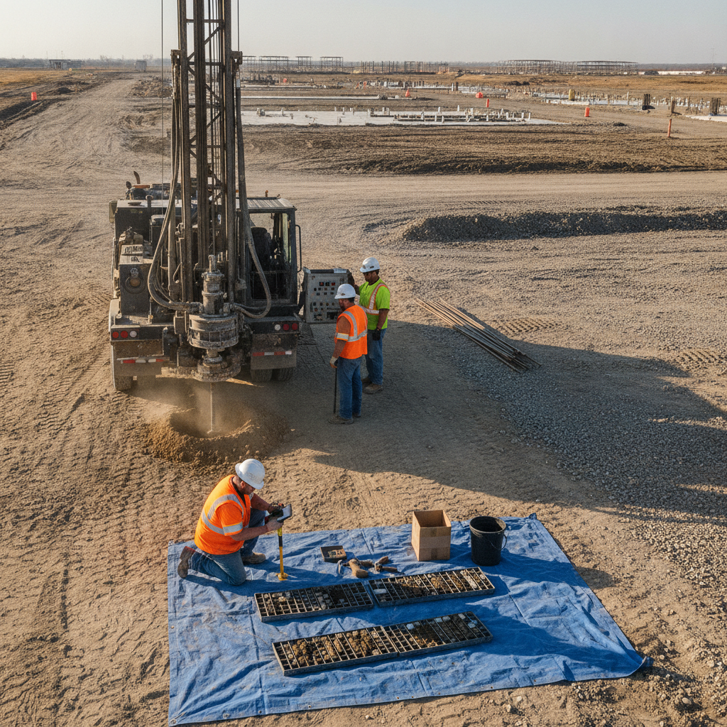
The most common method for geotechnical investigation is the use of truck-mounted or track-mounted drill rigs to advance hollow-stem augers into the ground. The augers remove soil as they rotate, creating a borehole. At specific intervals, the drilling is paused to perform testing and retrieve samples. The choice of equipment depends on site accessibility and anticipated subsurface conditions. For large, open data center sites, a truck-mounted rig is often efficient, while track-mounted rigs are better for navigating softer ground or uneven terrain. The key to a successful investigation is not just drilling the hole but collecting high-quality, representative soil samples. This is typically achieved using a split-spoon sampler, which is driven into the undisturbed soil at the bottom of the borehole. The recovered sample allows engineers to visually classify the soil, note its moisture content, and perform laboratory tests. This hands-on analysis is a critical part of the site engineering services that inform the final Geotechnical soil report and subsequent site plan design.
Decoding the Standard Penetration Test (SPT) and N-Values
The Standard Penetration Test (SPT) is the workhorse of geotechnical investigations in North America. The test is performed by driving a standard 1.375-inch inside diameter split-spoon sampler into the soil at the bottom of the boring. The sampler is driven a total of 18 inches using a 140-pound hammer dropped from a height of 30 inches. The number of hammer blows required to drive the sampler for each 6-inch interval is recorded. The sum of the blows for the second and third intervals is the SPT “N-value.” The N-value is a crucial indicator of soil density and consistency. A low N-value (e.g., 2-4) in sand indicates very loose soil, while a high N-value (e.g., >50) suggests very dense conditions. In clays, N-values correspond to consistency, from very soft to hard. This data is fundamental for calculating bearing capacity, estimating settlement, and designing the foundation system. A qualified Professional Engineer uses these N-values, along with lab testing results, to provide specific recommendations for the foundation design and any necessary ground improvement techniques.
Determining Boring Depth and Spacing for Large Footprints
Data centers are massive structures, and their influence on the underlying soil extends deep into the ground. Therefore, soil boring test depths must be sufficient to characterize all soil strata that will be significantly stressed by the building’s load. A common rule of thumb is to extend borings to a depth where the increase in vertical stress from the foundation is less than 10% of the existing effective overburden stress. For a large mat foundation, this can mean borings extending 50 to 100 feet or more below the proposed foundation level. The spacing of borings is equally critical for characterizing the site and identifying any problematic soil variations. For a large, uniform data center footprint, a grid pattern is often used, with borings typically spaced 100 to 200 feet apart. Closer spacing may be required in areas with complex geology or where heavy equipment pads are planned. This strategic layout ensures the civil engineering team has a comprehensive 3D model of the subsurface, minimizing the risk of encountering unexpected conditions during construction and supporting a robust site development plan.
How to Interpret a Geotechnical Soil Boring Log
The soil boring log is the primary deliverable from the field investigation. It is a graphical representation of the subsurface conditions encountered in a single borehole. A typical log includes several key columns of information: depth, sample number and type, visual soil classification (using the Unified Soil Classification System, or USCS), and graphical symbols. Crucially, it also includes the SPT N-values, groundwater level observations, and notes from the field geologist or engineer. Reading a boring log allows the design team to visualize the soil profile. For example, a log might show 10 feet of loose sand (low N-values) overlying a thick layer of stiff clay (higher N-values), with the groundwater table noted at 8 feet. This information immediately flags potential challenges, such as the need for dewatering during excavation and the unsuitability of the upper sand layer for supporting heavy loads. The boring log is a foundational document for all subsequent civil engineering and structural design, providing the raw data for settlement analysis and foundation design.
Identifying High-Risk Conditions: Rock Refusal and Groundwater
Two of the most significant findings in a soil boring program are auger or sampler “refusal” and the presence of a shallow groundwater table. Refusal occurs when the drill rig can no longer advance the boring, typically indicating the presence of very dense soil, boulders, or bedrock. The depth to refusal is a critical design parameter, as it may dictate the feasibility of certain foundation types or require expensive rock excavation. The Geotechnical engineer must differentiate between refusal on a lone boulder versus competent bedrock, which may require additional investigation like rock coring. A high groundwater table presents numerous challenges for site development. It can increase excavation costs due to the need for dewatering systems, affect soil bearing capacity, and create long-term issues with hydrostatic pressure on basement walls and foundations. The soil boring test must accurately record the depth at which groundwater is first encountered and the stabilized water level after a period of observation. This data is essential for designing effective drainage design, waterproofing systems, and ensuring compliance with stormwater management regulations.
Our Approach to Geotechnical Investigations
At RSP Engineers, we treat the geotechnical investigation as the first phase of design, not just a preliminary checkbox. Our process begins with a thorough desktop study, reviewing geological maps and existing data to anticipate site conditions. We then collaborate with the developer and structural engineer to design a boring program tailored to the specific facility layout and loading. Our field oversight ensures high-quality sampling and accurate data collection. We believe that a well-planned investigation, integrated with our civil engineering and site development services, is the most effective way to de-risk a project. We translate the raw data from the Geotechnical soil report into actionable design recommendations that balance performance, cost, and constructability, ensuring a smooth transition from site investigation to foundation construction.
Common Issues and Challenges
Even with a well-planned program, challenges can arise. The most common issue is encountering unexpected subsurface variability between boring locations, such as a buried channel of soft soil or an abrupt change in bedrock depth. This requires adaptive field decisions, such as adding supplemental borings to better define the anomaly. Another challenge is accurately determining the stabilized groundwater level, which can fluctuate seasonally. This may necessitate installing a piezometer for longer-term monitoring. Finally, discrepancies between the geotechnical report’s assumptions and the final structural loads can lead to redesigns. Clear communication between the Geotechnical engineer, structural engineer, and Civil Engineer near me is essential to mitigate these risks throughout the design and permitting process.
Your Foundation for Success Starts Here
A data center’s success is built from the ground up. A comprehensive geotechnical investigation is the most critical investment you can make to mitigate subsurface risk, control costs, and ensure a predictable construction schedule. The team at RSP Engineers integrates expert Geotechnical Engineering with our full suite of site engineering services to provide a clear path forward for your mission-critical project. From initial borings and foundation design recommendations to full site development and permitting, we deliver the data-driven insights you need. Contact us today to discuss your project’s specific geotechnical requirements and build with confidence.
Conclusion
In data center development, assumptions are liabilities. A proactive and thorough geotechnical investigation, centered on a well-planned soil boring test program, is non-negotiable. It transforms unknown subsurface risks into manageable design parameters, directly influencing foundation design, site grading, and stormwater management strategies. The data from boring logs and SPT N-values provides the empirical basis for a resilient and cost-effective design, safeguarding the project against costly construction delays and long-term performance issues. Ultimately, a sound understanding of the ground beneath is the first and most important step in successful site development for any mission-critical facility.
FAQs
-
A soil boring test uses a drill rig to create a small-diameter hole deep into the ground, allowing for SPT testing and sampling at various depths. A test pit is a large excavation, typically dug with a backhoe to a depth of 10-15 feet. Test pits allow for direct visual inspection of the shallow soil strata in a wider area but are limited in depth. Borings are essential for deep foundation design, while test pits are useful for utility trenching and shallow foundation investigations.
-
There’s no magic number, as it depends on site geology and the building’s structural system. However, a reasonable starting point for a 200,000 sq ft footprint would be a grid of 12 to 20 borings. The final number would be determined by a licensed Geotechnical engineer based on the anticipated uniformity of the site and the specific loading conditions of the proposed data center.
-
Poor soil doesn’t necessarily kill a project, but it does increase costs. If a Geotechnical soil report reveals weak or compressible soils, the engineering team will evaluate ground improvement options. These could include over-excavation and replacement with engineered fill, aggregate piers (stone columns), or deep foundation systems like piles or drilled shafts. The final solution depends on a cost-benefit analysis integrated into the overall site development budget.