
Case Study: Geotechnical and Civil Engineering for a Miami-Dade County Roadway Redevelopment on NW 74th Avenue, Florida
A project case study on RSP Engineers’ integrated geotechnical and civil engineering services for the redevelopment of a heavy-truck roadway in a Miami-Dade County, Florida industrial corridor.
Project Overview
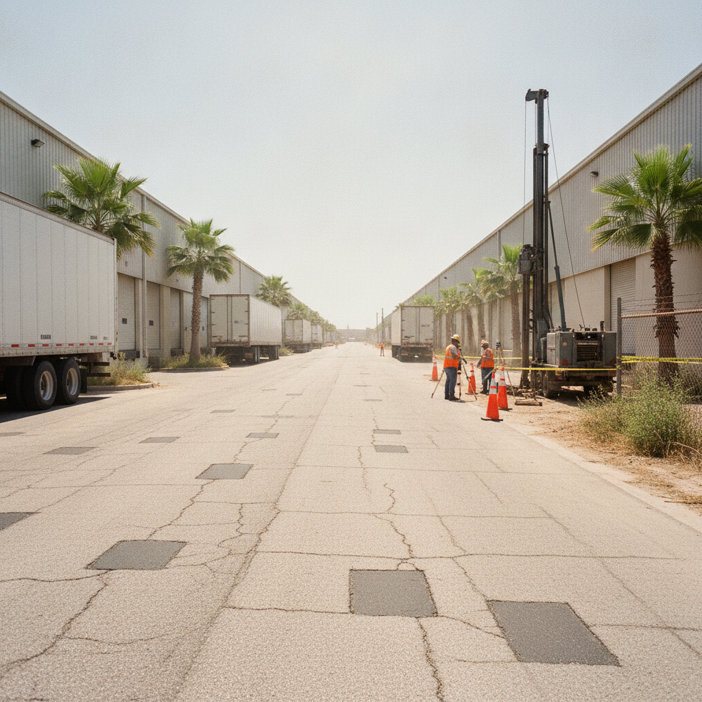
RSP Engineers has been engaged by Miami-Dade County to provide comprehensive Geotechnical Engineering and civil engineering services for the redevelopment of a section of NW 74th Avenue and its intersection with NW 52nd Street. This corridor is a vital artery within a dense district of warehouses, distribution centers, and logistics facilities, subjecting the pavement to sustained, heavy axle loads from semi-trailers and other commercial vehicles. The County’s objective is to rehabilitate the roadway to ensure long-term performance, improve safety, and enhance drainage. The core of this project lies in integrating two critical disciplines. A standalone pavement replacement might fail prematurely if underlying soil issues are not addressed. Similarly, a geotechnical study is only useful when its findings are translated into a practical and constructible civil engineering design. By pairing these services, RSP Engineers provides a holistic solution, ensuring the new pavement section is designed based on a thorough understanding of the subgrade conditions, traffic loading, and stormwater management requirements. This approach is designed to deliver a more cost-effective, resilient roadway, minimizing the need for future interventions.
Site and Regulatory Context
Project at a Glance
| Category | Details |
|---|---|
| Location | NW 74th Avenue and NW 52nd Street, Miami-Dade County, Florida |
| Client / Owner Type | County Government / Public Works |
| Project Type | Existing Roadway Redevelopment / Rehabilitation |
| Scale | Corridor section within an active industrial and logistics district |
| RSP Engineers Scope | Geotechnical Investigation and Civil Engineering Design |
| Key Deliverables | Subsurface Investigation, Pavement Section Design, Roadway and Drainage Plans, Utility Coordination, Construction Documents |
The project is situated within an established industrial area, characterized by heavy daily truck traffic and limited right-of-way. Any engineering solution must account for the need to maintain access to adjacent businesses throughout the design and construction phases. The design is governed by the standards and specifications of Miami-Dade County’s public works and regulatory departments, which oversee roadway geometry, pavement design, drainage design, and utility installations. Navigating the regulatory framework for a public roadway project involves careful coordination with multiple county agencies. Permitting requirements vary by jurisdiction, and every project team should confirm the applicable standards with the local, state, regional, and federal authorities that hold review authority over the site. For this engagement, the permitting process includes reviews for compliance with roadway standards, environmental resource management for stormwater, and coordination with franchised utility providers operating within the public right-of-way. A successful permit submittal package must demonstrate full compliance with all adopted codes and standards.
Engineering Challenges
The redevelopment of an active industrial roadway presents several distinct engineering challenges. The primary concern is designing a pavement section capable of withstanding the high-repetition, heavy-axle loads characteristic of a logistics hub. This requires a deep understanding of the subsurface soil conditions, as a weak or variable subgrade is a common point of failure for even the thickest asphalt sections. The project’s Geotechnical engineer must accurately characterize these conditions to inform the pavement design. Effective stormwater management is another critical challenge. Over decades of adjacent development, the original drainage infrastructure may have become undersized or less effective. The new design must adequately convey stormwater runoff to prevent localized flooding and pavement edge saturation, which can weaken the road base. Furthermore, all work must be carefully sequenced to minimize disruption to the surrounding businesses, requiring detailed Maintenance of Traffic (MOT) planning. Finally, the presence of numerous underground utilities necessitates precise location and coordination to avoid costly and dangerous conflicts during construction.
RSP Engineers’ Scope of Services
To address the project’s unique challenges, RSP Engineers is delivering a comprehensive scope of integrated site engineering services. Our team’s work is structured to move seamlessly from subsurface analysis to final construction documents. Subsurface Investigation and Geotechnical Report: This involves performing a Soil boring test program and laboratory testing to characterize the engineering properties of the subgrade soils and provide recommendations for the pavement design. Pavement Condition Evaluation and Design: Our team assesses the existing pavement and develops a new pavement section specifically engineered for the anticipated heavy truck traffic loading. Roadway Geometry, Grading, and Drainage Design: This includes preparing a full Site plan design for the roadway, ensuring proper lane widths, cross-slopes, and grading to support a new, comprehensive stormwater management system. Utility and Right-of-Way Coordination: We are responsible for identifying existing utilities, coordinating any necessary relocations with providers, and ensuring the entire design fits within the public right-of-way. Construction Document Preparation: RSP Engineers will produce a complete set of signed and sealed plans and specifications ready for public bidding and construction, detailing every aspect of the roadway redevelopment.
Technical Highlights
The success of this project hinges on several key technical activities that bridge the gap between geotechnical findings and civil design. Each step is critical to developing a robust and constructible solution. Subsurface Investigation for an Existing Roadway Unlike new construction, investigating an existing roadway requires a strategic approach to drilling and sampling. The scope includes a program of soil borings to determine the soil profile and groundwater levels beneath the pavement. A detailed Geotechnical soil report is then prepared, which characterizes the subgrade’s strength and suitability. This report is the foundational document for the pavement design, as it identifies weak soil layers that could compromise the longevity of the new road surface. Pavement Evaluation Under Heavy-Truck Loading The pavement design must go beyond generic standards. The process involves quantifying the expected traffic volume and, most importantly, the mix of vehicle types, especially multi-axle trucks. This data is used to calculate the design life in terms of Equivalent Single Axle Loads (ESALs). The civil engineering team uses these calculations, along with the data from the Geotechnical soil report, to engineer a specific pavement section—including the thickness of the asphalt, base, and sub-base layers—that can withstand the projected loading without premature cracking or rutting. Roadway Geometry, Grading and Drainage Review The civil design component addresses the roadway’s geometry to ensure it meets current safety and operational standards. This includes verifying lane widths, cross-slopes for proper sheet flow, and longitudinal grades. A key focus is the drainage design, which is being evaluated to ensure it has the capacity to handle storm events and prevent water from ponding on the pavement or infiltrating the subgrade, which is a primary cause of pavement failure. Utility and Right-of-Way Coordination Working within a mature industrial corridor means navigating a dense web of existing underground utilities, including water, sewer, gas, power, and communications. Our scope includes extensive utility coordination, typically involving subsurface utility engineering (SUE) to verify the horizontal and vertical location of existing infrastructure. This proactive step is essential for creating a conflict-free design and avoiding costly delays and change orders during construction. Sequencing Work on an Active Industrial Corridor Construction cannot shut down the surrounding logistics operations. A critical deliverable is a detailed Maintenance of Traffic (MOT) plan, also known as a Temporary Traffic Control (TTC) plan. This plan phases the construction work to ensure that access to warehouses and distribution centers is maintained at all times. It includes specifications for lane closures, detours, signage, and flagging operations to ensure the safety of both the construction crews and the public.
What This Means for Similar Projects
The challenges faced on this Miami-Dade County project are common to industrial and commercial corridors across the nation. For developers, facility owners, and public works departments planning similar roadway projects, this case study offers a key takeaway: an integrated geotechnical and civil engineering approach is not a luxury, but a necessity for long-term performance. Separating these scopes often leads to overly conservative (and expensive) designs or, worse, premature failures when pavement sections are placed on unverified subgrades. By investing in a thorough subsurface investigation and allowing those findings to directly inform the civil engineering design, owners can build more resilient infrastructure. This is particularly true for sites with heavy-duty loading requirements, such as data centers, manufacturing plants, and intermodal logistics facilities. A unified design team ensures seamless communication, efficient problem-solving, and a final product that is both durable and cost-effective.
Partner with RSP Engineers
Whether you are a public agency managing critical infrastructure or a private developer planning a new industrial facility, the performance of your roadways is paramount. RSP Engineers provides the integrated expertise needed to deliver resilient and reliable pavement and site infrastructure. Our teams of Civil Engineers and geotechnical professionals work collaboratively to solve complex challenges. Contact us today to discuss your project’s needs for Geotechnical Engineering, civil engineering design, and comprehensive permitting support.
Conclusion
In conclusion, the NW 74th Avenue roadway redevelopment project exemplifies the value of a holistic engineering strategy. By combining a detailed Geotechnical Engineering investigation with a robust civil engineering design, RSP Engineers is providing Miami-Dade County with a comprehensive plan for a durable, long-lasting infrastructure asset. This integrated approach to roadway engineering directly addresses the primary failure modes of industrial pavements, ensuring the final construction will serve the needs of this vital economic hub for years to come.
FAQs
-
A geotechnical investigation is crucial because many road failures are caused by issues beneath the pavement, not just the surface material. A Geotechnical soil report identifies weak subgrade soils, a high water table, or other conditions that must be addressed to ensure the new pavement has a stable foundation and achieves its intended design life.
-
Designing for heavy trucks requires calculating the cumulative loading over the road’s lifespan, expressed as Equivalent Single Axle Loads (ESALs). This calculation, combined with the subgrade strength data from the Soil boring test program, allows engineers to determine the required thickness and material specifications for each layer of the pavement structure (asphalt, base, and sub-base) to prevent premature fatigue and rutting.
-
Utility coordination involves identifying all existing utilities within the project limits, both through records research (e. g. , 811 tickets) and physical location services (subsurface utility engineering). The design team then works to avoid conflicts with the proposed improvements. If conflicts are unavoidable, the team coordinates directly with the utility owners to plan and design necessary relocations.