
Grading Plan Essentials for Florida Coastal Site Development
A guide for developers on preparing a civil engineering grading plan for Florida coastal sites. Learn about FEMA flood zones, CCCL, stormwater management, and permitting.
Understanding the Regulatory Landscape: FEMA, FDEP, and Local Ordinances
The first step in any coastal project is a thorough analysis of the regulatory environment. A coastal grading plan must satisfy several overlapping jurisdictions. The Federal Emergency Management Agency (FEMA) establishes flood hazard areas through its Flood Insurance Rate Maps (FIRMs). These maps dictate the Base Flood Elevation (BFE), which is the minimum elevation for the lowest floor of a structure to be protected from a 1%-annual-chance flood. Your grading plan must demonstrate compliance with these elevations, often with additional ‘freeboard’ required by local ordinances. The Florida Department of Environmental Protection (FDEP) administers the Coastal Construction Control Line (CCCL) program. The CCCL defines the portion of the beach-dune system that is subject to severe fluctuations due to a 100-year storm. Any excavation, grading, or construction seaward of this line requires a separate, often rigorous, FDEP permit. Finally, local city and county governments impose their own specific requirements related to zoning compliance, stormwater, and setbacks, which must be integrated into the overall site development plan.
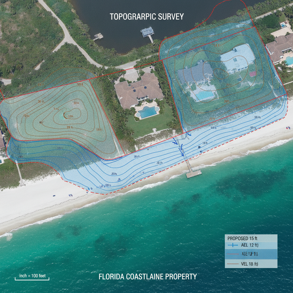
Topographic and Boundary Surveys: The Foundation of Your Grading Plan
FEMA Flood Zone Grading Strategy Comparison
| Feature | Zone AE (Coastal) | Zone VE (Coastal High Hazard) |
|---|---|---|
| Minimum Finished Floor Elevation | Must be elevated to or above the Base Flood Elevation (BFE), plus any local freeboard. | Lowest horizontal structural member must be elevated to or above the BFE, plus freeboard. |
| Foundation Type | Fill, stem-wall, or pile foundations are generally acceptable. Enclosed areas below BFE require flood vents. | Must be open pile or column foundations. No solid foundation walls or obstructions allowed below BFE. |
| Use of Structural Fill | Permitted to elevate the building pad to meet FFE requirements. Compensatory storage may be required. | Strictly prohibited for structural support of buildings. Limited use for minor site grading is allowed. |
| Stormwater Outfall Design | Can often utilize infiltration systems (exfiltration trenches) due to sandy soils and high water table. | Must be designed to withstand wave action and high-velocity flow. Hardened structures are often necessary. |
| Required Certifications | An Elevation Certificate is required after construction to verify FFE. | An Elevation Certificate and a V-Zone Design Certificate from a Professional Engineer are required. |
An accurate and comprehensive survey is the non-negotiable foundation of a coastal grading plan. A standard boundary survey is insufficient. For coastal sites, the survey must be performed by a Florida-licensed Professional Surveyor and Mapper (PSM) and include detailed topographic information, capturing precise elevations across the entire property. This data is used to create the existing condition model against which all proposed changes are designed and measured. Crucially, the survey must identify key coastal features such as the Mean High Water Line (MHWL), any existing dunes, coastal vegetation, and the location of the CCCL. It also needs to document existing infrastructure, such as seawalls, revetments, and utility access points. This level of detail is essential for the civil engineering team to perform accurate earthwork calculations, design effective drainage design, and ensure the proposed improvements are correctly situated relative to regulatory lines and environmental constraints.
Designing for Storm Surge and Flood Resilience
The primary goal of a coastal grading plan is to ensure the development is resilient to flooding and storm surge. This is achieved by establishing a proposed Finished Floor Elevation (FFE) that is safely above the required BFE plus any local freeboard. The grading plan details how the site will be modified to support this elevation, whether through the importation of structural fill, the use of stem-wall foundations, or elevating the structure on piles (pilings). When fill is used, the plan must also address compensatory storage. This engineering principle ensures that adding fill to the floodplain does not reduce its storage capacity, which could increase flood risk for adjacent properties. The grading design must balance the volume of fill added with an equivalent volume of excavated area. Furthermore, for enclosed areas below the BFE, the Florida Building Code requires the installation of hydrostatic vents to allow floodwaters to enter and exit, preventing catastrophic foundation failure from hydrostatic pressure.
Coastal Stormwater Management and Drainage Design
Stormwater management on coastal sites presents unique challenges due to high water tables, sandy soils, and the proximity to sensitive water bodies. A conventional detention pond may not be feasible. The drainage design must therefore employ strategies tailored to these conditions. Sandy soils often allow for excellent infiltration, making systems like French drains, exfiltration trenches, and pervious pavements effective for managing runoff quality and quantity. However, the design must carefully consider the seasonal high water table elevation to ensure these systems have the capacity to function correctly. Another critical factor is preventing saltwater intrusion into the freshwater lens and managing the discharge of stormwater to avoid erosion or contamination of coastal waters. The permitting process through the local Water Management District (WMD) will heavily scrutinize the stormwater plan to ensure it meets stringent water quality and quantity criteria before discharge.
Erosion and Sediment Control During and After Construction
Coastal environments are highly susceptible to erosion from wind and water. A robust Erosion and Sediment Control (ESC) plan is a mandatory component of the overall grading and site development package. During construction, this involves implementing Best Management Practices (BMPs) such as staked silt fences, floating turbidity barriers in adjacent waters, and stabilized construction entrances to prevent sediment from leaving the site. Post-construction, the grading plan must incorporate permanent stabilization measures. This includes specifying appropriate slopes that resist erosion and establishing native, salt-tolerant vegetation that can quickly anchor the soil. In some cases, hard armoring like riprap or seawalls may be necessary, which requires additional specialized engineering and permitting. The goal is to create a stable landform that withstands both everyday weather and significant storm events.
Utility Coordination in a High Water Table Environment
Integrating utilities into a coastal site requires careful planning within the grading design. The high water table can complicate the installation of water, sewer, and electrical conduits. The grading plan must be developed in concert with the utility coordination plan to ensure that trenches for utilities do not compromise the structural integrity of foundations or drainage systems. This is especially critical on sites where deep foundations like piles are used. Materials must be specified to resist corrosion from the salty environment. For sewer systems, connections must be watertight to prevent infiltration of groundwater, which would overwhelm treatment systems. The plan must also ensure that all utility infrastructure, such as manholes and valve boxes, are set at finished grades that align with the final topography and meet ADA compliance for accessible routes where necessary.
RSP Engineers’ Approach to Coastal Grading Plans
At RSP Engineers, our process begins with comprehensive due diligence. We start by analyzing FEMA maps, local ordinances, and CCCL data to establish a clear regulatory framework. We then commission and closely review detailed topographic and bathymetric surveys to understand the site’s unique characteristics. This data forms the basis of our integrated design approach, where our Civil Engineers collaborate to create a cohesive plan. Our design process balances earthwork to minimize costs, engineers a resilient stormwater management system suited for coastal conditions, and coordinates seamlessly with structural and utility plans. We prepare meticulous permit submittals for all relevant agencies, including the local municipality, Water Management District, and FDEP. Our goal is to anticipate and address potential agency review comments proactively, streamlining the approval process and keeping the project on schedule.
Common Issues and Pitfalls in Coastal Site Grading
Developers often encounter several common hurdles with coastal grading plans. A primary issue is underestimating the volume and cost of fill material required to achieve the necessary design elevations. Another pitfall is a failure to properly account for the seasonal high water table in the drainage design, leading to system failure and site flooding. Inadequate erosion control during construction can lead to stop-work orders and fines. Perhaps the most significant challenge is navigating the complex and often lengthy permitting process. Incomplete applications or designs that fail to address specific agency criteria can result in multiple rounds of review comments, causing costly delays. A frequent oversight is a conflict between proposed structural pilings and underground utility pathways, which requires costly redesign if not caught early in the site plan design phase.
Partner with Florida’s Coastal Engineering Experts
Navigating the complexities of a coastal grading plan requires specialized expertise and a deep understanding of Florida’s unique regulatory and environmental landscape. The team at RSP Engineers provides the comprehensive site engineering services needed to bring your coastal project to life. From initial due diligence and site plan design to final permitting and construction administration, we are your trusted partners. Contact us today to discuss how our experience in coastal site development and stormwater management can ensure your project is built on a solid, resilient foundation.
Conclusion: A Resilient Foundation for Coastal Development
In conclusion, preparing a grading plan for a Florida coastal site is a highly specialized task that forms the bedrock of a successful project. It is an intricate exercise in balancing development goals with the stringent demands of flood protection, environmental preservation, and regulatory compliance. A well-executed grading plan, supported by a robust drainage design and a proactive approach to permitting, is the key to mitigating risk and ensuring the long-term viability of any coastal development. Investing in experienced civil engineering expertise from the outset is the most critical step toward achieving a resilient and approvable design.
FAQs
-
The Base Flood Elevation (BFE) is the regulatory elevation set by FEMA for the 100-year flood. The Design Flood Elevation (DFE) is the elevation your design team actually uses for the structure; it is typically the BFE plus a ‘freeboard’ (e. g. , 1-3 feet) as required by the local building code for an added margin of safety.
-
If any portion of your proposed work, including grading, excavation, or construction, falls seaward of the Coastal Construction Control Line (CCCL), you will likely need a CCCL permit from the Florida Department of Environmental Protection. This is a separate and more intensive review process than local building permits.
-
A high water table limits the effectiveness of deep infiltration systems. Your drainage design must be carefully engineered to function within the available soil depth above the water table. This often involves using wider, shallower systems like exfiltration trenches or incorporating pervious pavements to manage stormwater management requirements.