
Evaluating Wetland Impacts From Data Center Development
A civil engineering guide to evaluating and permitting wetland impacts for data center projects. Learn about delineation, Section 404 permits, and mitigation strategies.
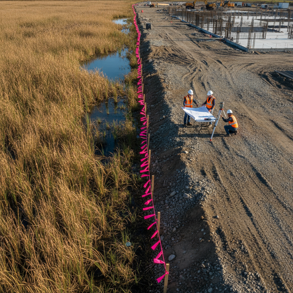
The Critical First Step: Wetland Delineation and Functional Assessment
Before any site layout can be finalized, the precise boundaries of all jurisdictional wetlands must be established through a formal wetland delineation. This technical process is performed by environmental scientists who identify wetlands based on three mandatory criteria: the presence of hydrophytic vegetation, hydric soils, and wetland hydrology, as defined in federal manuals. The resulting delineation report and survey map form the basis for all subsequent design and permitting efforts. It is crucial that this delineation is submitted to the U.S. Army Corps of Engineers (USACE) for verification through a Jurisdictional Determination (JD), which provides a legally defensible boundary for project planning. Beyond simply mapping the boundaries, a functional assessment is often required to quantify the ecological value of the wetlands that may be impacted. Various methodologies are used across the country to score wetland functions such as wildlife habitat, water quality improvement, and flood storage. This assessment is not just a formality; it directly influences the amount of compensatory mitigation required for any unavoidable impacts. A higher-functioning wetland will require more extensive and costly mitigation, making this a critical financial and logistical component of the project’s site development plan.
Navigating the Avoid-Minimize-Mitigate Sequence
Comparison of Wetland Permit Types for Development Projects
| Feature | Nationwide Permit (NWP) | Individual Permit (IP) |
|---|---|---|
| Impact Threshold | Typically limited to 0.5 acres of permanent wetland impact, with lower thresholds for streams. | Required for impacts exceeding NWP thresholds; no upper acreage limit, but justification is rigorous. |
| Review Timeline | Generally 3-6 months, assuming a complete application and no major issues. | Typically 12-18 months or longer, due to public notice and extensive inter-agency review. |
| Public Notice Requirement | Not typically required, unless specified by the reviewing agency for a specific project. | Mandatory. A public notice is issued, and comments are solicited from the public and other agencies. |
| Mitigation Requirements | Required for impacts over 0.1 acres. May be sourced from a mitigation bank. | Always required. Often involves more complex mitigation plans and higher mitigation ratios. |
| Level of Agency Scrutiny | Streamlined review focused on compliance with the terms and conditions of the specific NWP. | Intensive, project-specific review covering public interest, environmental impacts, and alternatives analysis. |
| Project Schedule Risk | Lower risk, with a more predictable timeline for qualifying projects. | High risk, with a long and less predictable timeline that can significantly impact project delivery. |
Federal regulations governing wetlands are built on a foundational principle: the avoid-minimize-mitigate sequence. Project applicants must demonstrate to regulatory agencies that they have followed this hierarchy in their site plan design. First, the developer must make every practicable effort to avoid impacting wetlands altogether. This can involve reconfiguring building footprints, access roads, and utility corridors to steer clear of sensitive areas. This is the most scrutinized step in the review process, and agencies expect a thorough analysis of alternatives. If impacts cannot be completely avoided, the next step is to minimize them to the greatest extent possible. This could include using retaining walls to reduce fill slopes near a wetland edge, specifying construction mats for temporary access to limit soil compaction, or adjusting stormwater outfall locations. Only after all practicable avoidance and minimization measures have been exhausted can the project propose compensatory mitigation for the remaining unavoidable impacts. Failure to adequately document this sequence is a common reason for permit delays and requests for additional information from review agencies.
Understanding Types of Wetland Impacts
Not all impacts are treated equally. During the permitting process, impacts are categorized based on their nature and duration, with each type having different regulatory implications. The most significant are permanent impacts, which involve the permanent loss of a wetland area through filling, grading, or flooding. These typically result from the placement of building pads, parking lots, and permanent infrastructure. Permanent impacts almost always require compensatory mitigation. Temporary impacts are those that disturb a wetland for a limited duration, with the expectation that the area will be restored to its pre-construction condition. Examples include temporary access roads, utility line installation trenches, or staging areas. A detailed restoration plan is required for these areas. Finally, secondary impacts, also known as indirect impacts, are effects on wetlands adjacent to the project area, such as changes in hydrology from new impervious surfaces or fragmentation of habitat. These can be more difficult to quantify but are increasingly scrutinized by agencies, especially for large-scale land development projects like data centers.
Federal Permitting Pathways: Nationwide vs. Individual Permits
The primary federal authority for regulating wetland impacts comes from Section 404 of the Clean Water Act, administered by the USACE. Depending on the scale and nature of the proposed impacts, a project may qualify for one of two main permit pathways. For projects with minor impacts, a general permit known as a Nationwide Permit (NWP) may be applicable. NWPs are a streamlined authorization for specific activities that result in minimal adverse environmental effects, typically with acreage impact thresholds (e.g., under 0.5 acres). While streamlined, they still require a formal application and agency verification of compliance. When a project’s impacts exceed the thresholds of any available NWP, an Individual Permit (IP) is required. This is a much more intensive, project-specific review process that involves a detailed public interest review, a public notice period, and deeper coordination with other federal and state agencies. The timeline for an IP can be a year or longer, compared to a few months for an NWP. Permitting requirements vary by jurisdiction, and every project team should confirm the applicable standards with the local, state, regional, and federal authorities that hold review authority over the site. Choosing the correct permitting pathway is a critical strategic decision that profoundly affects the project schedule and budget.
The Role of Inter-Agency Coordination
Securing a federal wetland permit is rarely a single-agency affair. The USACE often serves as the lead federal agency, but they are required to coordinate with other key stakeholders. The U.S. Environmental Protection Agency (EPA) has oversight authority and can elevate review or even veto a permit decision. State environmental agencies typically conduct a parallel review to ensure compliance with state water quality standards and wetland protection rules, a process known as Water Quality Certification. This inter-agency coordination is a formal part of the process. Furthermore, if the project may affect federally listed threatened or endangered species, consultation under the Endangered Species Act with the U.S. Fish and Wildlife Service is required. Similarly, if the site has the potential for historical or archaeological significance, coordination with the State Historic Preservation Officer is necessary. A successful permit submittal strategy anticipates the concerns of all these agencies and provides the necessary documentation upfront to facilitate a smooth and efficient review.
Quantifying and Sourcing Wetland Mitigation
For unavoidable permanent impacts, compensatory mitigation is required to offset the loss of wetland functions. The amount of mitigation is determined by applying a ratio based on the acreage and functional value of the impacted wetlands. For example, destroying one acre of high-quality forested wetland might require creating or restoring three or more acres of similar wetland. This calculation, driven by the functional loss, is a key point of negotiation with regulatory agencies. Developers have several options for satisfying their mitigation obligations. The most common and preferred method is purchasing credits from an approved mitigation bank. These are large, restored, or created wetland sites where credits are sold to offset impacts elsewhere within a defined service area. If a bank is not available, an in-lieu fee program may be an option, where a developer pays a fee to a government or non-profit entity that then becomes responsible for implementing the mitigation. The least common option, permittee-responsible mitigation, requires the developer to design, construct, and monitor a mitigation project themselves, which carries significant long-term risk and liability.
RSP Engineers’ Approach to Wetland Permitting Strategy
At RSP Engineers, we integrate wetland strategy into the earliest stages of project due diligence and site planning. Our approach is built on minimizing risk and creating schedule certainty for our data center clients. We begin with thorough desktop analysis and field reconnaissance to identify potential regulatory constraints before a property is even acquired. Our team of environmental scientists and Civil Engineers works collaboratively on the site plan design to exhaust all practicable avoidance and minimization options. We facilitate early, proactive consultation with regulatory agencies to build consensus and identify potential issues before a formal application is submitted. Our permit applications are meticulously prepared to be clear, complete, and defensible, anticipating agency questions and providing robust justification for the project’s design. By managing the entire process from delineation through permit issuance and compliance monitoring, we provide the comprehensive site engineering services needed to navigate this complex landscape and keep mission-critical projects on track.
Common Pitfalls in Wetland Permitting for Data Centers
Even sophisticated developers can encounter pitfalls in the wetland permitting process. A common mistake is relying on outdated or incomplete wetland mapping, leading to surprise discoveries during due diligence that force costly redesigns. Another frequent issue is underestimating the timeline for agency review, especially for an Individual Permit, which can jeopardize financing and construction schedules. Failing to rigorously document the avoidance and minimization analysis is a red flag for regulators and a primary cause of requests for additional information. Design changes made late in the process can also create significant problems. A minor shift in a utility line or access road can trigger new wetland impacts, potentially pushing a project over an NWP threshold and into the much longer IP process. Finally, developers sometimes fail to budget adequately for mitigation, which can be a substantial project cost. The price of mitigation bank credits can fluctuate based on supply and demand, and securing them should be part of the early financial planning for the project. Frequently Asked Questions (FAQs) What is a Jurisdictional Determination (JD)? A Jurisdictional Determination, or JD, is an official determination by the USACE regarding the presence and extent of federally regulated waters, including wetlands, on a property. An Approved JD (AJD) is a legally binding document that confirms the boundaries of jurisdictional wetlands and is typically valid for five years. It provides the certainty needed for land development planning and financing. How long does a wetland permit typically take to obtain? The timeline varies significantly. A project qualifying for a Nationwide Permit (NWP) might receive authorization in 3 to 6 months. A project requiring an Individual Permit (IP) involves a much more extensive review and public notice process, often taking 12 to 18 months or even longer, depending on the complexity and controversy of the project. Can we start site work before the wetland permit is issued? No. You cannot begin any work, including clearing, grading, or filling, within a jurisdictional wetland or its regulated buffer area without the required federal and state permits in hand. Starting work prematurely can result in significant fines, restoration orders, and project delays. All other site development activities outside of regulated areas may be able to proceed, but this must be carefully coordinated. What happens if we impact a wetland without a permit? Impacting a wetland without a permit is a violation of the Clean Water Act and can lead to severe consequences. These include federal and state enforcement actions, stop-work orders, substantial monetary penalties (calculated on a per-day basis), and requirements to restore the impacted area. It can also create significant negative publicity and jeopardize future projects. Does the type of wetland affect the mitigation cost? Absolutely. The cost of compensatory mitigation is directly tied to the type and functional quality of the impacted wetland. Impacting a rare or high-functioning system like a mature forested wetland will require a higher mitigation ratio and more expensive mitigation credits than impacting a lower-quality, common wetland type. The functional assessment is key to determining this cost. How do secondary impacts affect my project’s overall impact ledger? Regulatory agencies are increasingly requiring mitigation for secondary impacts. For example, if your site’s stormwater management system alters the hydrology of an adjacent, non-impacted wetland, the agency may require mitigation for that functional degradation. These impacts are added to your project’s total impact ledger and can increase overall mitigation requirements and costs.
Partner with RSP Engineers for Your Data Center Project
Navigating the complexities of wetland regulations requires a partner with deep technical expertise and a strategic understanding of the development process. The team at RSP Engineers provides the comprehensive civil engineering and environmental permitting support needed to de-risk your data center project. From initial due diligence and wetland delineation to agency negotiation and securing your final Section 404 permit, we manage every step to ensure your project stays on schedule and on budget. Contact us today to discuss your site selection and development challenges.
Conclusion
For data center developers, wetlands represent one of the most significant variables in site selection and project execution. A successful outcome depends on a proactive, informed strategy that begins long before the first shovel hits the ground. By accurately delineating resources, thoughtfully applying the avoid-minimize-mitigate sequence, and engaging a skilled Professional Engineer to navigate the complexities of wetland permitting, developers can transform a potential project-killer into a manageable component of the overall land development process. This strategic approach is fundamental to delivering mission-critical infrastructure on time.
FAQs
-
Evaluating Wetland Impacts From Data Center Development requires careful planning, qualified engineering, and compliance with the applicable codes and permits.
-
Getting Evaluating Wetland Impacts From Data Center Development right protects safety, supports regulatory compliance, and avoids costly redesigns or delays.
-
RSP Engineers provides licensed expertise and end-to-end support for Evaluating Wetland Impacts From Data Center Development, from early planning through permitting.