
Data Center Wetland Delineation Guide
A guide for data center developers on the wetland delineation process in Florida, covering the three-parameter approach, permitting, and site plan integration. Learn how to de-risk your project.
Understanding Jurisdictional Wetlands in Florida
Not every wet patch of land is a regulated wetland. In Florida, wetlands are considered “jurisdictional” if they fall under the authority of state and/or federal agencies, primarily the Florida Department of Environmental Protection (FDEP) and the U.S. Army Corps of Engineers (USACE). These agencies enforce regulations derived from the federal Clean Water Act and state statutes. A jurisdictional determination is the formal process of verifying the presence and boundaries of these regulated areas. This determination is essential because any proposed impacts, such as filling or dredging, will require extensive permitting. The delineation process identifies these jurisdictional areas by applying a standardized, science-based methodology. For data center developers, confirming these boundaries early in the due diligence phase is crucial. The presence of extensive or strategically located wetlands can render a site unsuitable for the large, contiguous footprint required for a data center campus. It directly influences the project’s feasibility, layout, and the complexity of the required civil engineering and stormwater management design.
The Three-Parameter Approach to Wetland Identification
Wetland Parameter Field Indicator Comparison
| Parameter | Primary Field Indicators | Secondary Field Indicators & Notes |
|---|---|---|
| Wetland Hydrology | Surface water, high water table, saturation in upper 12 inches, evidence of inundation (e.g., water marks, sediment deposits). | Drainage patterns, oxidized rhizospheres on living roots, local soil survey data. Indicators must show that saturation/inundation is present for a sufficient duration during the growing season. |
| Hydric Soils | Hydrogen sulfide odor, gleyed (gray/blue) soil colors, concretions, sandy soils with organic matter streaking. | Mottles (spots of contrasting color), depleted matrix. A Munsell soil color chart is used for official classification. A Geotechnical soil report may note some of these features but is not a substitute for a delineation. |
| Hydrophytic Vegetation | More than 50% of the dominant plant species from all strata (trees, shrubs, herbs) are rated as obligate, facultative wet, or facultative. | Visual observation of plant adaptations like buttressed tree trunks or shallow root systems. The National Wetland Plant List (NWPL) is the standard reference for species ratings. |
The cornerstone of a defensible wetland delineation is the three-parameter approach, which requires that three specific criteria be met in a single location for it to be classified as a wetland. This methodology ensures that determinations are based on objective, verifiable evidence rather than casual observation. An area must exhibit indicators of wetland hydrology, hydric soils, and hydrophytic vegetation. All three parameters must be present under normal circumstances for the area to be delineated as a wetland. This technical approach is critical for ensuring the delineation is upheld during agency review. A delineation that fails to properly document all three parameters can be challenged by regulatory agencies, forcing costly and time-consuming re-investigations. For a data center project, such a delay can have significant financial consequences. The successful application of this method requires experienced environmental scientists who can interpret subtle field indicators and document them meticulously for permit submittals. A Geotechnical soil report can sometimes provide initial clues, but it is not a substitute for a formal delineation.
Field Delineation Methods and Data Collection
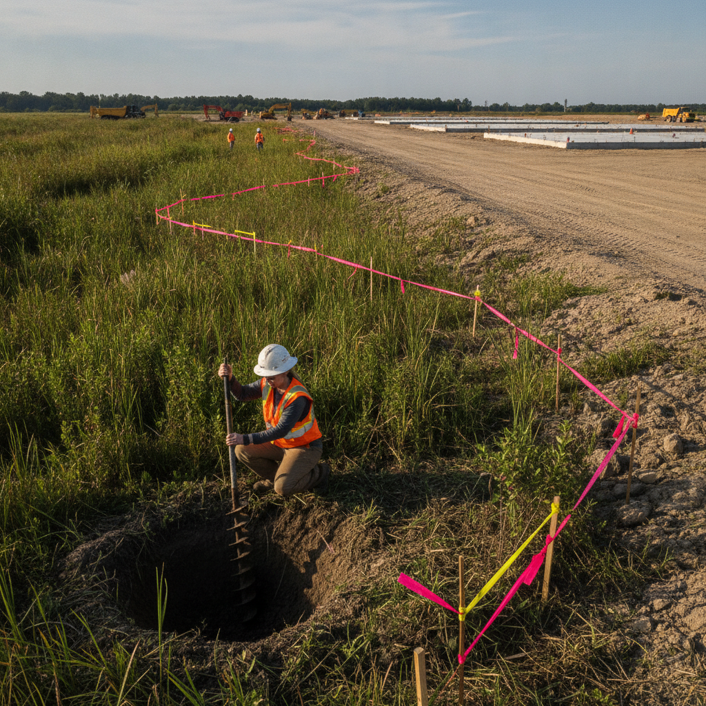
The physical process of wetland delineation involves systematic fieldwork. Environmental scientists establish transects across the property, moving from obvious upland areas to potential wetland areas. Along these transects, they establish sample plots to perform detailed analysis. At each plot, they document the plant species to determine if the vegetation is predominantly hydrophytic vegetation (adapted for life in saturated soil conditions). They also use soil augers to excavate and examine the soil profile for indicators of hydric soils, such as specific colors, mottles, and odors associated with anaerobic conditions. Finally, they search for direct and indirect evidence of wetland hydrology, such as water marks on trees, sediment deposits, or a saturated water table. The boundary is then flagged where one or more of the three parameters ceases to be present. These flag locations are then surveyed and mapped by a professional surveyor, creating the official wetland line that becomes a hard constraint in the site plan design. This entire process is documented on USACE Wetland Determination Data Forms, which are a critical part of the submittal package for permitting.
Seasonal Considerations and Timing for Accurate Delineation
Performing a wetland delineation at the right time of year is crucial for accuracy, especially in Florida’s climate. The state’s distinct wet and dry seasons can significantly influence the visibility of key indicators. For example, hydrologic indicators like surface water or a high water table may be absent during a prolonged dry season or drought, making it more difficult to prove the hydrology parameter. Conversely, attempting a delineation during a major flood event can be equally misleading. Ideally, fieldwork should be conducted during the normal wet season when the water table is at its expected high and vegetation is in its growing season, making identification easier. A delineation performed under atypical conditions may be questioned by regulatory agencies, potentially requiring a follow-up site visit or additional data collection. A skilled consultant will understand how to interpret evidence of the seasonal high water table even during dry periods, but the most defensible delineations are timed to coincide with normal climatic conditions to ensure a smooth agency review and avoid challenges to the jurisdictional determination.
From Field Flags to Site Plan: Mapping and Permitting Implications
Once the wetland boundary is flagged, surveyed, and mapped, it transitions from an environmental finding to a core engineering constraint. This line becomes a critical layer in the project’s CAD or GIS files, directly influencing every aspect of the site development plan. The civil engineering team must design the data center footprint, access roads, parking areas, and critical infrastructure to avoid or minimize impacts to the delineated wetlands and any associated buffers required by local zoning compliance ordinances. Any unavoidable impacts trigger a rigorous permitting process that requires demonstrating that all practical measures to avoid and minimize impacts have been taken. If impacts are approved, compensatory mitigation is almost always required. The wetland boundary also heavily influences the stormwater management strategy, as the location of ponds, swales, and other drainage features must be integrated around these preserved areas. Effective utility coordination is also essential, as routing power, water, and fiber optic lines must be planned to circumvent these sensitive zones.
Navigating the Permitting Maze: USACE and FDEP Jurisdictional Review
After the delineation report is complete, it is submitted to the USACE and FDEP for verification. The developer can request an Approved Jurisdictional Determination (AJD) from the USACE, which is a legally binding confirmation of the wetland boundaries on a property. This provides a high degree of certainty for planning and investment. The state-level equivalent is typically handled through the Environmental Resource Permit (ERP) application process, where the FDEP or a local Water Management District reviews and verifies the boundaries as part of the overall project approval. This agency review process can take several months and may involve site visits by agency staff to verify the field findings. A well-documented report based on a thorough field investigation is the best way to facilitate a smooth review. Any discrepancies or poorly supported conclusions in the permit submittals can lead to requests for additional information, delaying the project timeline. This is where experienced Civil Engineers and environmental consultants add immense value by ensuring the submittal is complete, defensible, and anticipates agency questions.
Our Approach to Wetland Delineation and Site Integration
At RSP Engineers, we treat wetland delineation as an integral part of the overall site development strategy, not an isolated environmental task. Our process begins with a thorough desktop analysis of publicly available data, including aerial imagery, soil surveys, and topographic maps, to identify potential wetland areas before ever setting foot on site. This allows us to plan our field investigation efficiently. Our environmental scientists then conduct the fieldwork, meticulously documenting the three parameters and working with professional surveyors to precisely map the boundaries. The key to our approach is seamless integration. The verified wetland data is immediately incorporated into our civil engineering design workflow. This allows our team to optimize the site layout, develop a compliant drainage design, and plan for utility coordination while respecting environmental constraints from day one. This proactive approach minimizes the risk of late-stage redesigns, streamlines the permitting process, and provides our clients with a clear and realistic path forward for their data center project.
Common Pitfalls in Data Center Wetland Assessments
Even with a defined process, several common issues can arise during wetland assessments for large sites. One major pitfall is underestimating the impact of local wetland buffer requirements. Many Florida counties and municipalities have their own upland buffer rules that extend development restrictions beyond the delineated wetland line, further constraining the usable area. Another common issue is failing to properly account for wetland impacts on the overall drainage design, which can lead to significant challenges in meeting stormwater management regulations. Other problems include relying on outdated or incomplete delineations from previous landowners, which may not be accepted by agencies. Misinterpreting seasonal indicators during an unusually dry or wet period can also lead to an inaccurate boundary that is later challenged. Finally, a lack of early coordination between the environmental consultant and the civil engineering team can result in a site plan that is not viable once the final wetland lines are established, forcing a reactive and costly redesign process. Frequently Asked Questions What is the difference between a wetland delineation and a wetland assessment? A wetland delineation is the technical process of identifying and mapping the precise boundary of a wetland on a property. A wetland assessment, or functional assessment, is a subsequent step that evaluates the quality and functions of the delineated wetland (e.g., wildlife habitat, water quality benefits). This assessment is often required when calculating mitigation needs for unavoidable wetland impacts. How long is a jurisdictional determination valid in Florida? An Approved Jurisdictional Determination (AJD) from the U.S. Army Corps of Engineers is typically valid for five years. After this period, if development has not commenced, a new delineation and verification may be required, as site conditions can change over time. State and Water Management District verifications may have similar time limits tied to the life of the associated Environmental Resource Permit (ERP). Can we build on a property that has wetlands? Yes, but with significant constraints. The primary goal of regulators is to ensure developers avoid and minimize impacts to wetlands. If impacts are unavoidable for a project to be viable, a rigorous permitting process is required to obtain authorization. This process typically requires providing compensatory mitigation, often through the purchase of credits from an approved mitigation bank, to offset the authorized losses. What are wetland mitigation and mitigation banking? Wetland mitigation is the process of compensating for unavoidable impacts to wetlands. This can involve creating, restoring, or enhancing wetlands on- or off-site. A more common and streamlined approach in Florida is purchasing credits from a permitted mitigation bank. A mitigation bank is a large, restored wetland area where credits are sold to developers to satisfy their permitting requirements for wetland impacts. How do delineated wetlands affect the stormwater management plan for a data center? Delineated wetlands are a major constraint on stormwater management design. Stormwater ponds, swales, and control structures cannot be placed within jurisdictional wetlands. The drainage design must route runoff around these areas, and discharge points must be carefully located to avoid negative hydrologic impacts to the preserved wetlands. This often requires creative civil engineering solutions to meet water quality and quantity regulations on a constrained site.
Partner with RSP Engineers for Your Data Center Site Development
Successfully navigating the complexities of wetland delineation and permitting is fundamental to keeping your data center project on schedule and on budget. The expert team at RSP Engineers provides comprehensive site engineering services, integrating environmental science with robust civil engineering. We manage the entire process, from initial due diligence and accurate delineation to strategic site plan design and efficient agency coordination. Let us help you de-risk your investment and build a clear path through the regulatory landscape. Contact us today to discuss your project’s unique environmental and permitting challenges.
Conclusion: Proactive Delineation is Project Assurance
For data center developers in Florida, wetland delineation should be viewed as a critical project assurance tool, not a regulatory hurdle. A proactive, accurate, and defensible delineation provides the certainty needed to make informed investment decisions, optimize site plan design, and streamline the complex permitting process. By understanding and respecting these environmental constraints from the outset, you can avoid costly delays and build a foundation for a successful project. Integrating this process into your core site development strategy is the first step toward powering the future on solid ground.
FAQs
-
Data Center Wetland Delineation Guide requires careful planning, qualified engineering, and compliance with the applicable codes and permits.
-
Getting Data Center Wetland Delineation Guide right protects safety, supports regulatory compliance, and avoids costly redesigns or delays.
-
RSP Engineers provides licensed expertise and end-to-end support for Data Center Wetland Delineation Guide, from early planning through permitting.