
Data Center Karst Terrain Engineering
A guide for data center developers on the unique civil engineering challenges of karst terrain, including geotechnical investigations, foundation design, and stormwater management in Florida.
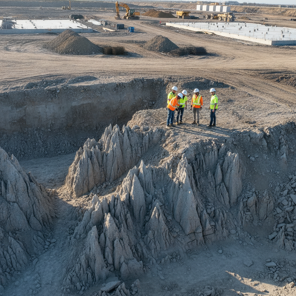
Understanding Karst Geology and Its Impact on Mission-Critical Facilities
Karst is a type of landscape formed from the dissolution of soluble rocks, primarily limestone and dolomite. Over millennia, slightly acidic groundwater seeps through fractures, slowly dissolving the rock and creating a complex network of underground conduits, caves, and voids. This process results in a highly irregular and often unstable subsurface. Key features of karst topography include sinkholes (dolines), springs, disappearing streams, and a highly erratic bedrock surface known as pinnacled rock. For a data center, which has zero tolerance for differential settlement, these features present a profound risk. The presence of undetected subsurface voids can lead to ground subsidence or sudden collapse. The weight of a heavily loaded data hall slab can trigger the collapse of a weak soil roof over a limestone cavity. This inherent instability makes a thorough understanding of the site-specific geology the most critical first step in any karst development project.
The Challenge of Top-of-Rock Variability and the Epikarst Zone
Comparison of Foundation Systems for Data Centers in Karst
| Foundation System | Primary Application in Karst | Key Advantages | Major Considerations & Risks |
|---|---|---|---|
| Mat Slab on Improved Ground | Sites with shallow, less severe karst features where ground improvement is economically viable. | Distributes loads over a wide area; can be cost-effective if grouting is limited. | High risk if subsurface investigation is incomplete; potential for residual differential settlement; extensive QA/QC for grouting is required. |
| Micropiles | Transferring moderate to heavy loads through voids and cutters to competent rock at variable depths. | High flexibility in installation around obstructions; minimal vibration; excellent for retrofitting or targeted support. | Higher cost per unit capacity than other options; requires specialized contractors; extensive rock socketing needed for tension loads. |
| Drilled Shafts (Caissons) | Supporting very heavy, concentrated column loads by reaching deep, high-capacity bedrock. | Extremely high load capacity; can be visually inspected before concrete placement (in dry conditions). | Large equipment required; potential for installation issues with collapsing soil or high groundwater flow; costly. |
| Aggregate Piers / Stone Columns | Improving bearing capacity of soils overlying bedrock, but not directly addressing deep voids. | Increases soil stiffness and reduces settlement; relatively fast installation. | Not a solution for significant voids or pinnacled rock; effectiveness is highly dependent on surrounding soil conditions. |
| Driven Piles | Generally unsuitable for karst terrain due to risk of pile damage or deflection on pinnacled rock. | Rapid installation in suitable (non-karst) soil profiles. | High risk of premature refusal on rock pinnacles; can damage piles or cause deviation, compromising load capacity. |
In typical construction, engineers expect a relatively consistent top-of-rock elevation. In karst, this assumption is invalid. The bedrock surface is often a chaotic landscape of sharp limestone pinnacles and deep, soil-filled crevices known as cutters. This extreme variability in bearing capacity across short distances makes conventional foundation design impossible. One column footing might rest on solid rock, while another just feet away could be situated over a deep clay-filled cutter, leading to severe settlement issues. Compounding this is the epikarst, a highly weathered, fractured, and porous layer at the top of the limestone. This zone acts like a sponge, channeling significant amounts of water and contributing to further dissolution and instability. The epikarst is often mechanically weak and must be carefully evaluated during the geotechnical investigation. Failure to characterize both the top-of-rock geometry and the epikarst’s properties can lead to flawed foundation design and long-term structural problems for the data center.
Advanced Geotechnical Investigation Strategies for Karst Sites
A standard grid of soil borings is dangerously inadequate for characterizing a karst site. A boring can easily miss a large void by just a few feet or terminate on a rock pinnacle, giving a false impression of solid bedrock. A robust investigation program is essential and must employ a multi-faceted approach to build a reliable subsurface model. This is a critical phase that informs all subsequent civil engineering decisions. Advanced geophysical methods are a cornerstone of this process. Techniques like Electrical Resistivity Imaging (ERI) and Microgravity surveys can map variations in subsurface density and conductivity, helping to identify potential voids, clay-filled cutters, and fracture zones over large areas. The results of these surveys are then used to target a high-density pattern of soil boring test locations and rock coring to confirm the geophysical anomalies. A comprehensive Geotechnical soil report based on this integrated data is the foundational document for de-risking the project.
Foundation Design and Ground Improvement in Karst Terrain
Once the subsurface is adequately characterized, the engineering team can design a foundation system to mitigate the identified risks. Standard shallow foundations are rarely feasible without extensive ground improvement. If the investigation reveals significant voids or weak zones, techniques like compaction grouting or pressure grouting may be required. This involves injecting a low-mobility grout into the subsurface to fill voids, densify loose soils, and create a more uniform and stable foundation subgrade. More commonly, deep foundations are the preferred solution. Micropiles and drilled shafts are designed to transfer the massive loads of the data center through the unpredictable upper layers and into competent, non-karstic bedrock at depth. This approach bypasses the epikarst and soil-filled cutters entirely, providing a stable foundation. The selection between different deep foundation types depends on the specific subsurface profile, load requirements, and vibration sensitivity of the data center equipment. This is a key part of the site plan design.
Stormwater Management and Groundwater Protection in Sensitive Karst Aquifers
In karst terrain, the connection between surface water and groundwater is direct and rapid. Stormwater runoff can quickly enter the aquifer through sinkholes and solution channels with little to no natural filtration. This makes stormwater management a critical environmental and permitting challenge. Traditional infiltration-based designs, such as French drains or unlined percolation ponds, are often prohibited because they can introduce pollutants directly into the drinking water supply and can alter hydrogeology, potentially inducing new sinkholes. The drainage design for a data center on a karst site must prioritize containment and controlled discharge. This typically involves using fully lined retention or detention ponds to prevent infiltration. All conveyance systems must be watertight. In some jurisdictions, regulations may forbid any new concentrated discharge of stormwater, requiring complex systems that disperse water over a wide area. Navigating the permitting process with Florida’s Water Management Districts and the FDEP requires a robust plan that demonstrates comprehensive groundwater protection.
RSP Engineers’ Approach to Karst Site Development
At RSP Engineers, we employ a phased, risk-based methodology for data center projects in karst terrain. Our process is designed to identify and mitigate fatal flaws early, providing developers with the confidence to proceed. We integrate our site engineering services closely with geotechnical experts to create a seamless workflow. Phase 1: Due Diligence and Feasibility Assessment. We begin with a thorough desktop study of geological maps, historical aerials, and existing well data to assess the baseline karst risk before any ground is broken. Phase 2: Comprehensive Subsurface Investigation. We manage and direct a multi-tool investigation, combining geophysical surveys with a targeted boring and coring program to build a detailed 3D model of the subsurface. Phase 3: Integrated Foundation and Site Design. Our Civil Engineers work concurrently with geotechnical and structural engineers to select and design the most appropriate foundation system, ground improvements, and a compliant stormwater management system. Phase 4: Proactive Agency Permitting. We engage with regulatory agencies early, presenting our investigation findings and engineering solutions to build trust and streamline the permit submittals process. Phase 5: Rigorous Construction Administration. We provide on-site oversight during critical construction phases, such as pile installation and grouting operations, to ensure the design is implemented correctly and to manage any unforeseen conditions discovered during excavation.
Common Pitfalls in Karst Data Center Projects
Developing data centers in karst terrain is fraught with potential missteps that can derail a project. One of the most common is underfunding the geotechnical investigation, which inevitably leads to costly surprises during construction. Discovering a 50-foot-deep, clay-filled cutter beneath a critical column line after sitework has begun can trigger months of delays and seven-figure change orders. Another frequent issue is a disconnect between the geotechnical findings and the civil design. A drainage design that fails to account for the high-risk nature of the karst aquifer will be rejected by regulators, forcing a costly and time-consuming redesign. Finally, an unrealistic project contingency is a major pitfall. Karst projects inherently carry a higher level of uncertainty, and the budget must reflect the potential need for extensive ground improvement or foundation redesigns.
Partner with RSP Engineers for Your Mission-Critical Karst Project
The complexities of data center development in karst terrain demand a highly experienced engineering partner. The risks are too high for a standard approach. RSP Engineers provides the specialized expertise in site development, geotechnical coordination, and Florida permitting necessary to navigate these challenging projects. Our team of Florida Licensed Engineers understands the unique geology of the region and the rigorous demands of mission-critical facilities. From initial site selection and due diligence to detailed design and Construction Management Services, we provide the integrated solutions needed to deliver a stable, secure, and permittable data center. Contact our team today to discuss your project and learn how we can help you de-risk your investment and build with confidence on Florida’s complex ground.
Building Resilient Infrastructure on Complex Ground
Successfully engineering a data center in karst terrain is a testament to proactive risk management and specialized design. It requires moving beyond standard practice and embracing a comprehensive, data-driven approach to understanding and taming the subsurface. By investing in a thorough geotechnical investigation, selecting a resilient foundation design, and implementing a protective stormwater management plan, developers can overcome the challenges of karst. Ultimately, the goal is to transform a high-risk site into a secure foundation for critical digital infrastructure. With the right engineering partner, the complexities of karst geology become manageable variables in a successful project equation, ensuring the long-term stability and operational integrity of the facility.
FAQs
-
While site-specific, a prudent starting point for a project in known karst is a geotechnical and foundation contingency of 15-25% of the site and foundation budget, which is significantly higher than for a standard site. This contingency can be refined as more detailed geotechnical investigation data becomes available.
-
It depends on the size, location, and nature of the sinkholes. Small, stable paleosinks (ancient, soil-filled sinkholes) can often be remediated through over-excavation and backfilling or by using compaction grouting. Active or large sinkholes located directly under proposed critical structures would likely render a site unsuitable. A detailed stability analysis is required.
-
The most common cause of delay is the discovery of unforeseen subsurface conditions during construction, such as a large void or a pinnacle field that conflicts with the planned foundation layout. This is almost always a direct result of an inadequate initial geotechnical investigation.