
Data Center Geotechnical Monitoring During Construction
Learn why geotechnical monitoring is critical for data center construction. Our guide covers instrumentation, alert levels, and managing settlement risk for mission-critical facilities in Florida.
The Unique Geotechnical Demands of Mission-Critical Facilities
Data centers impose extreme and uniform loads on their foundations. A typical data hall can have floor loads exceeding 300 pounds per square foot (psf), far greater than a standard office building. This immense weight, combined with the vibration sensitivity of server equipment, requires a foundation system with exceptional stability. The primary goal is to prevent differential settlement, where one part of the foundation settles more than another, which can twist the structural frame and damage equipment. Furthermore, the construction process itself, particularly on sites requiring significant earthwork or soil improvement, introduces risks. The placement of massive fill pads, the use of surcharge loads to consolidate weak soils, and extensive construction dewatering activities can all induce ground movement. A comprehensive instrumentation and monitoring plan provides the necessary oversight to ensure these construction activities proceed as designed, confirming that the ground is responding as predicted by the Geotechnical soil report and protecting the project from costly delays and rework.
Key Geotechnical Instrumentation and Their Applications
Geotechnical Monitoring Instrumentation Comparison
| Instrument | Primary Purpose | Typical Alert Trigger | Data Center Application |
|---|---|---|---|
| Settlement Plate | Measure vertical settlement of ground surface or fill layers. | Settlement rate decreases to a pre-determined minimum (e.g., <0.1 inch/week). | Confirming primary consolidation is complete under surcharge loads before starting foundation work. |
| Inclinometer | Measure subsurface lateral (horizontal) displacement. | Lateral movement exceeds a fraction of the design tolerance (e.g., 0.5 inches). | Monitoring stability of deep excavations for utility vaults or basement structures; ensuring no movement toward adjacent properties. |
| Piezometer | Measure pore water pressure in the soil. | Pore water pressure dissipates to a certain percentage of its initial peak value. | Verifying the effectiveness of a surcharge program by tracking the reduction in water pressure as soils consolidate. |
| Vibration Monitor | Measure ground vibrations from construction activities. | Peak Particle Velocity (PPV) exceeds limits for sensitive structures or equipment. | Ensuring that pile driving or heavy compaction activities do not impact nearby operational facilities or sensitive utility lines. |
| Crack Gauge | Measure the change in width of a crack in an existing structure. | Crack width increases by a specified amount (e.g., 1 mm). | Monitoring adjacent buildings or structures for signs of distress caused by dewatering or excavation on the project site. |
| Survey Monitoring Point | Measure vertical and horizontal position of a specific point. | Movement exceeds survey tolerance or a pre-set displacement limit. | Tracking the stability of retaining walls, existing utility structures, and adjacent building foundations during construction. |
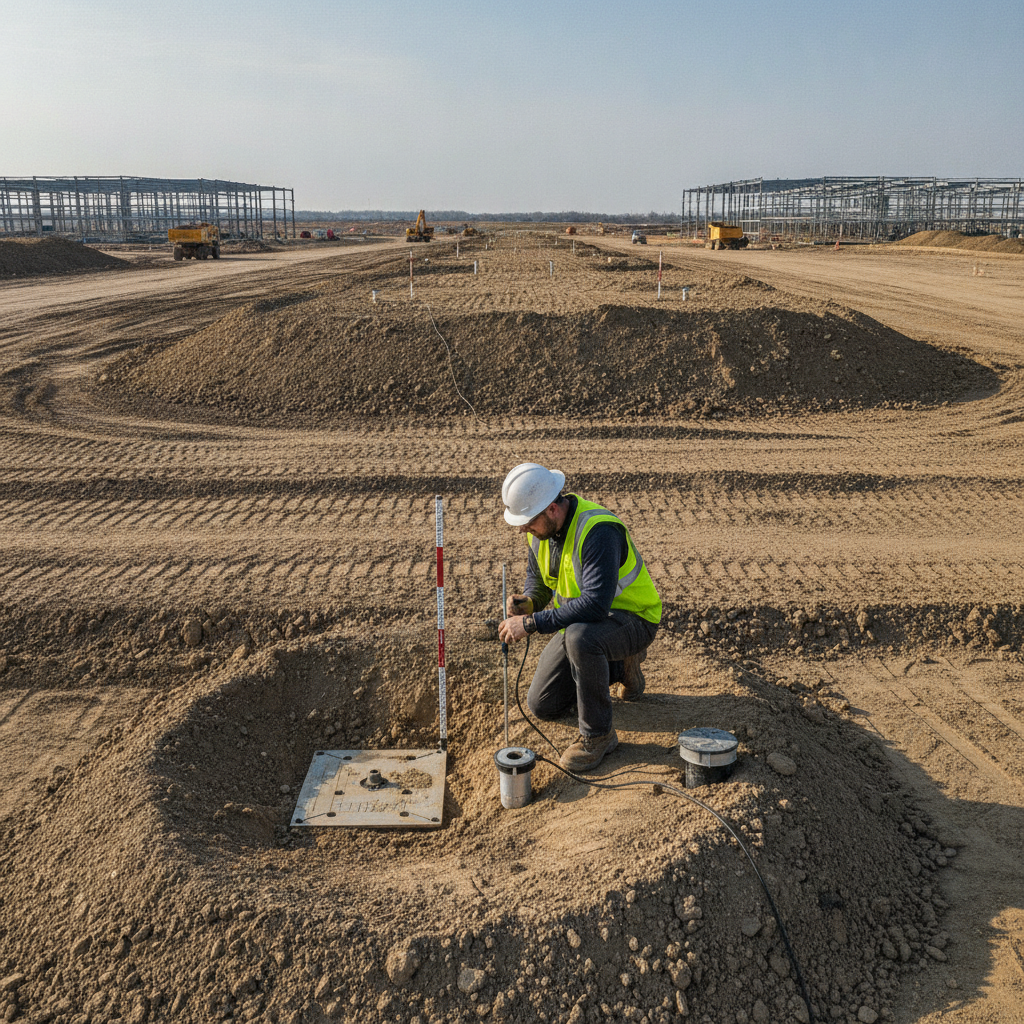
An effective monitoring program relies on a suite of specialized instruments to measure specific types of ground movement and pressure. The selection and placement of this equipment are determined by the site-specific soil conditions and the project’s design. A Professional Engineer specializing in geotechnical design will specify the required instrumentation to manage site risks effectively. Settlement Plates and Survey Monitoring The most direct way to measure vertical ground movement is with settlement plates. These are simple, robust instruments consisting of a steel plate placed at a specific elevation (often at the original ground surface or on top of a particular fill lift) with a riser pipe extending vertically. The top of the riser is surveyed regularly to track settlement over time. This data is crucial for verifying that soil consolidation under new fill or a surcharge load is occurring as anticipated and has reached an acceptable level before foundation construction begins. Inclinometers for Lateral Movement While settlement is a vertical issue, lateral or horizontal ground movement can be equally damaging, especially near deep excavations, retaining walls, or on sloped sites. Inclinometers are used to measure this subsurface horizontal displacement. A special casing with internal grooves is installed in a vertical borehole. A probe is then lowered into the casing to measure its tilt at various depths, providing a profile of lateral movement. This is critical for ensuring that excavation or dewatering activities are not causing instability or impacting adjacent properties and utilities. Piezometers for Pore Water Pressure Piezometers measure pore water pressure, which is the pressure of groundwater held within the soil. During soil consolidation, this pressure dissipates as water is squeezed out, and the soil becomes denser. Vibrating wire piezometers are commonly used to monitor this process in real-time. The data helps engineers confirm that a surcharge program is effectively strengthening the underlying soils and can be used to determine when the desired level of soil consolidation has been achieved, allowing the surcharge to be removed.
Monitoring Fill Placement and Surcharge Programs
Many Florida sites require significant site preparation, including the placement of engineered fill to raise site grades for stormwater management and flood protection. When underlying soils are weak or compressible, a surcharge program is often implemented. This involves placing a temporary mound of soil on top of the building pad area that is heavier than the final building load. This extra weight accelerates the soil consolidation process, squeezing water out of the compressible layers and strengthening them before the permanent structure is built. Geotechnical monitoring is the only way to scientifically manage this process. Settlement plates track the rate and total amount of consolidation, while piezometers monitor the dissipation of pore water pressure. The data is plotted over time, and when the settlement curve flattens out, it indicates that primary consolidation is complete. This data-driven approach allows the project team to confidently determine the optimal time to remove the surcharge and begin foundation work, avoiding both premature construction on unstable ground and unnecessary project delays.
Establishing Action Thresholds and Alert Levels
Raw data from instrumentation is useless without context. A critical part of any instrumentation and monitoring plan is the establishment of pre-defined action thresholds and alert levels. These are specific measurement values that, if reached, trigger a specific response from the project team. Typically, a tiered system is used to provide an early warning before a serious problem develops. For example, a ‘Green’ level indicates that measurements are within the expected range predicted by the geotechnical design parameters. A ‘Yellow’ or ‘Amber’ alert level might be set at 75% of the maximum predicted settlement, triggering a review of the data and increased monitoring frequency. A ‘Red’ alert level, set at the maximum tolerable limit, would trigger an immediate work stoppage and require the geotechnical engineer to assess the situation and recommend corrective action. This structured approach ensures that data is translated into timely, decisive action on site.
Managing Dewatering and Its Impact on Adjacent Structures
Lowering the groundwater table through construction dewatering is often necessary for deep foundation work and utility installation. However, this process can have unintended consequences. Lowering the water table increases the effective stress on underlying soils, which can cause settlement not only on the project site but also on adjacent properties. For a data center project located near existing structures or critical utilities, this presents a significant liability risk. A well-planned monitoring program is essential for managing these risks. Piezometers can be installed both on and off-site to monitor the extent of the groundwater drawdown. Survey monitoring points can be established on nearby buildings, roadways, and utilities to detect any settlement caused by the dewatering activities. This data provides a clear record of performance and allows the construction team to adjust dewatering methods if necessary to stay within acceptable limits, ensuring compliance and protecting against third-party claims.
Integrating Monitoring Data with Construction Phasing
The ultimate value of a geotechnical monitoring program is its integration into the daily management of the construction project. The data should not be an academic exercise but a tool that informs critical path decisions. For instance, the settlement data from a surcharge program directly dictates the schedule for foundation construction. The results from compaction testing on fill lifts determine when the next layer of soil can be placed. This requires seamless communication between the geotechnical consultant, the general contractor, and the owner. Effective construction administration ensures this data flows to the right people at the right time. Regular meetings to review monitoring results allow the team to anticipate milestones, such as the completion of soil consolidation, and adjust the construction sequencing accordingly. This proactive approach, guided by real-world data, helps optimize schedules, control costs, and ultimately reduces the risk profile of the entire site development project.
RSP Engineers’ Approach to Geotechnical Monitoring
At RSP Engineers, we integrate geotechnical monitoring as a core component of our site engineering services for mission-critical projects. Our process begins during the design phase, where we work closely with the Geotechnical engineer to interpret the findings of the Geotechnical soil report and develop a practical, site-specific instrumentation and monitoring plan. We clearly define the objectives, instrument types, locations, and frequency of readings. During construction, our team provides robust construction administration and oversight. We coordinate the installation of instrumentation with the contractor, establish a clear protocol for data collection and reporting, and hold regular meetings to analyze the results. Our focus is on translating complex geotechnical data into clear, actionable guidance for the project team. This hands-on approach ensures that the design intent is met and that potential issues are addressed proactively, safeguarding the project schedule and budget.
Common Challenges in Geotechnical Monitoring Programs
Even with a well-designed plan, challenges can arise. One of the most common issues is the damage of instrumentation by construction equipment. It is vital to clearly mark and protect all monitoring locations. Another challenge is the potential for instrumentation failure or erroneous readings, which requires experienced personnel to identify and troubleshoot. Clear communication protocols are essential to ensure that when an alert level is triggered, the information is relayed immediately to the decision-makers. Misinterpretation of data can also be a significant risk. A sudden change in a reading may not always indicate a structural problem; it could be related to a change in construction activity or even a weather event. This is why having an experienced geotechnical engineer as part of the team is critical. They provide the expert analysis needed to distinguish between normal trends and genuine warning signs, preventing unnecessary panic while ensuring that true risks related to unforeseen soil conditions are never ignored.
Partner with RSP Engineers for Your Data Center Development
The success of a multi-million dollar data center rests on the ground beneath it. Ensuring that foundation performance meets the stringent demands of mission-critical infrastructure requires specialized expertise. RSP Engineers provides comprehensive civil engineering and site development consulting for data center projects across Florida. We manage the entire process, from initial due diligence and permitting to the development and execution of a robust geotechnical monitoring program. Our expertise in site development, utility coordination, and construction administration ensures your project is built on a foundation of certainty. Contact us to discuss how we can help de-risk your next mission-critical development.
Conclusion: From Data to Decisions
Geotechnical monitoring during data center construction is an indispensable risk management tool. It transforms the invisible, subsurface environment into a set of measurable data points, providing the project team with the clarity needed to make critical decisions. By verifying design assumptions, providing an early warning of potential problems, and optimizing construction schedules, a well-executed monitoring program provides immense value. For developers of high-stakes data center projects, investing in a comprehensive geotechnical monitoring program is a direct investment in the long-term stability, performance, and success of their critical digital infrastructure and ensures proper settlement control.
FAQs
-
The frequency depends on the specific instrument and the construction activity. During critical phases, such as the initial placement of a heavy surcharge or active dewatering, readings from settlement plates and piezometers might be taken daily. As conditions stabilize, the frequency may be reduced to weekly or bi-weekly. The monitoring plan will specify these requirements.
-
If a pre-defined alert level is reached, the monitoring plan’s response protocol is activated. This typically involves immediately notifying the project manager and the geotechnical engineer. The first step is to verify the reading. If confirmed, the engineer will analyze all relevant data to determine the cause and recommend a course of action, which could range from increased monitoring to a temporary halt in specific construction activities.
-
While the Florida Building Code mandates that foundations be designed to address site-specific soil conditions, it does not typically prescribe a specific geotechnical monitoring program for all projects. However, for complex projects with poor soils, deep foundations, or significant earthwork, the building official or the Engineer of Record may require a monitoring program as a condition of the permitting approval to ensure public safety and structural integrity.