
A Developer’s Guide: What to Include in a Florida Subdivision Site Plan
Learn the essential components of a subdivision site plan in Florida, from zoning compliance and utility coordination to stormwater management. A guide by RSP Engineers.
Boundary and Topographic Survey: The Foundational Data Layer
Before any design work can begin, a precise and current survey of the property is non-negotiable. This isn’t just about identifying property lines; it’s about creating the foundational data layer upon which all other design elements are built. The boundary and topographic survey must accurately document existing conditions, including property corners, easements, rights-of-way, and visible utility infrastructure. It also provides critical elevation data, mapping the site’s contours and identifying high and low points. This topographic information is the basis for all subsequent grading design, drainage analysis, and earthwork calculations. An inaccurate survey can lead to flawed stormwater management models and incorrect utility profiles, causing major issues during construction. At RSP Engineers, we insist on working with a recent, certified survey to ensure our site development plans are built on a foundation of accuracy, preventing unforeseen challenges and budget overruns down the road.
Zoning and Land Use Compliance Analysis
Key Components of Preliminary vs. Final Site Plans
| Feature | Preliminary Plan Detail | Final Construction Plan Detail |
|---|---|---|
| Zoning Compliance | General layout showing lot counts, setbacks, and open space calculations to confirm feasibility. | Fully dimensioned lots, detailed setback lines, and final calculations for density and impervious surfaces. |
| Utility Design | Schematic layout showing conceptual routes for main lines and confirmed points of connection. | Detailed plan and profile sheets with pipe sizes, materials, slopes, inverts, and specific fitting locations. |
| Stormwater Management | Conceptual pond locations, preliminary drainage basin map, and initial water quality/quantity calculations. | Final pond grading, detailed hydraulic calculations, outlet control structure design, and supporting modeling reports. |
| Roadway Geometry | Centerline alignments with basic curve data and typical right-of-way cross-sections. | Complete horizontal and vertical geometry, stationing, curve data tables, and detailed pavement section specifications. |
| Landscaping & Lighting | General locations for required landscape buffers and conceptual placement of streetlights. | Specific plant schedules, irrigation plans, and photometric analysis demonstrating lighting level compliance. |
| Permitting Status | Submitted for initial agency feedback and conceptual approval. Used to secure zoning entitlements. | Fully engineered plans submitted for final construction permits from all jurisdictional agencies. |
A subdivision site plan is, at its core, a demonstration of compliance. The plan must clearly show that the proposed layout adheres to the local municipality’s specific zoning and land development regulations. This involves a thorough analysis of the property’s zoning district and any applicable overlay districts. Key elements that must be graphically represented and often tabulated on the plan include minimum lot sizes, lot widths, building setbacks (front, side, and rear), maximum building coverage, and density calculations (units per acre). Furthermore, the plan must address requirements for open space, recreation areas, and buffering from adjacent properties. Our engineers meticulously review local codes to ensure every aspect of the layout meets or exceeds these standards. Proving zoning compliance upfront is essential for a smooth agency review process. Failing to address a specific setback or density requirement is one of the most common—and avoidable—reasons for initial rejection of permit submittals.
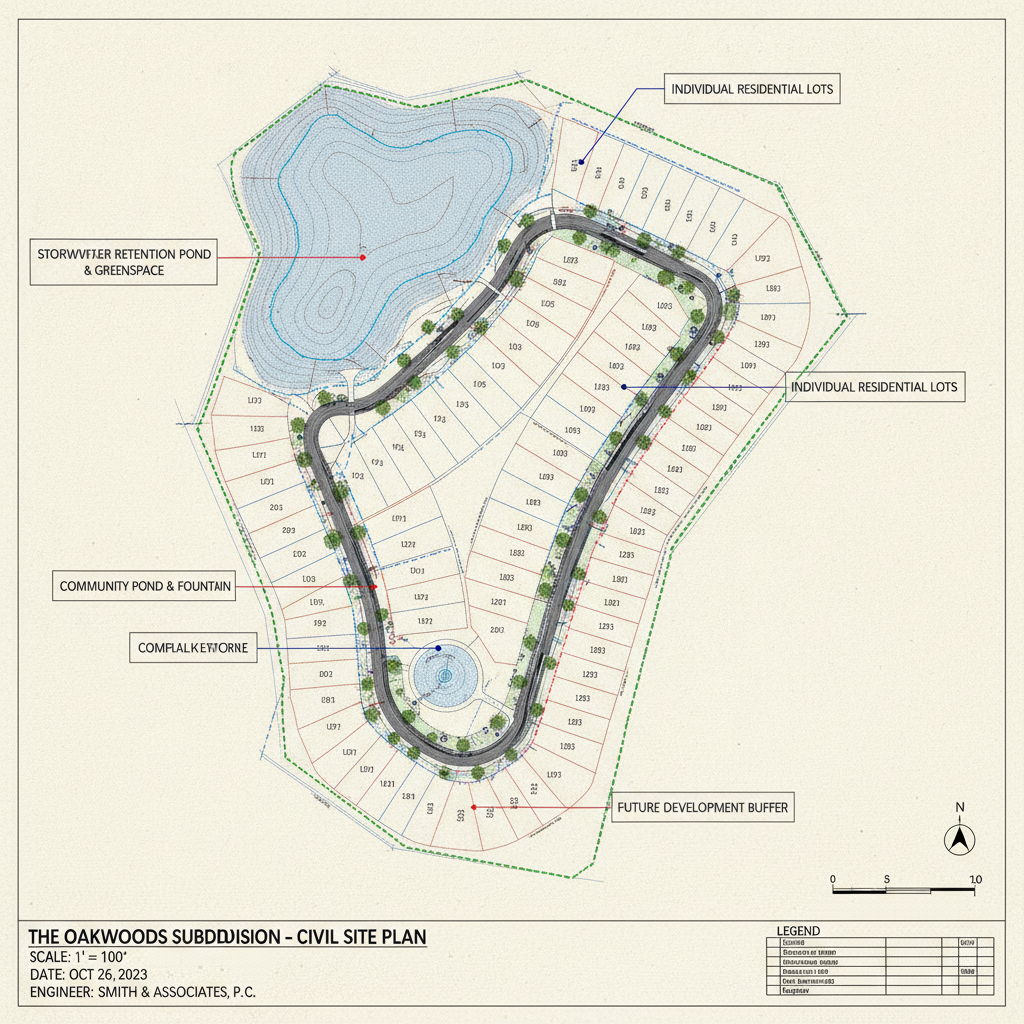
Site Layout and Geometric Design: Lots, Roads, and Common Areas
The heart of the subdivision plan is the geometric layout of its core components. This section details the precise configuration of individual lots, the internal roadway network, and any common areas. The plan must show lot lines with dimensions and bearings, lot and block numbering, and the total area for each parcel. The roadway design is equally critical, specifying right-of-way widths, pavement widths, curb types, and the geometry of all horizontal and vertical curves, ensuring safe and efficient traffic circulation. This part of the design also incorporates pedestrian infrastructure, such as sidewalks, crosswalks, and multi-use paths. All public-facing elements must be designed with careful attention to ADA compliance, ensuring accessible routes for all residents. The layout must balance market demands for desirable lots with the technical constraints of the site and the regulatory requirements for emergency vehicle access and logical traffic flow. This is a key area where experienced civil engineering adds immense value.
Comprehensive Utility Coordination and Design
A functional subdivision relies on a complex network of underground utilities. The site plan must include a detailed utility plan showing the proposed layout for potable water, sanitary sewer, and, where available, reclaimed water systems. This includes the location and sizing of all mains, service laterals, valves, fire hydrants, and manholes. The design must demonstrate sufficient capacity and pressure to serve the entire development, often requiring hydraulic modeling to validate the system’s performance. Effective utility coordination with local service providers is paramount. This process begins early in the design phase to confirm connection points, verify available capacity, and secure necessary easements. The plan must also account for other franchises like power, communications, and gas, showing the proposed alignment of these utilities to avoid conflicts. A failure in utility coordination can halt a project, making it one of the highest-risk items in site development.
Stormwater Management and Drainage Design
In Florida, managing stormwater is one of the most significant challenges in land development. The subdivision site plan must be accompanied by a comprehensive stormwater management plan that details how runoff will be collected, treated, and discharged. This involves a sophisticated drainage design that includes a network of inlets, pipes, and swales to convey water to treatment facilities, typically wet or dry retention/detention ponds. The engineering calculations must prove that the system complies with the stringent criteria of the local municipality and the regional Water Management District (WMD). This includes demonstrating that the post-development discharge rate does not exceed the pre-development rate and that the system provides adequate water quality treatment before discharge. The permitting for these systems is rigorous, and the design must be supported by detailed hydrologic and hydraulic modeling to gain approval.
Grading, Paving, and Erosion Control Plans
The grading plan provides a three-dimensional view of how the land will be shaped to accommodate the new infrastructure. It establishes proposed elevations for building pads (finished floor elevations), roads, and drainage features to ensure positive drainage away from structures and across the site. This plan is critical for balancing earthwork (cut and fill), which has a direct impact on construction costs. The grading plan works in concert with the drainage design to ensure the entire system functions as intended. This set of drawings also includes paving details, specifying the material cross-sections for roadways and parking areas. Additionally, a Sediment and Erosion Control Plan is required for all permit submittals. This plan outlines temporary measures, such as silt fences and turbidity barriers, that will be used during construction to prevent soil erosion and protect downstream water bodies, a key component of environmental compliance.
The RSP Engineers Approach to Subdivision Site Plan Development
At RSP Engineers, we approach subdivision design as a strategic, phased process designed to minimize risk and maximize value for our clients. Our methodology begins with thorough due diligence and feasibility studies to identify potential site constraints and opportunities before significant capital is invested. We then move to conceptual and preliminary design, where we work collaboratively with the client to establish a layout that meets their vision while satisfying all regulatory requirements for zoning compliance and environmental protection. Once the preliminary plat is approved, we advance to final engineering. This is where our team develops the detailed construction drawings, including comprehensive utility coordination, final drainage design, and all specifications necessary for bidding and construction. We manage the entire permitting process, submitting the plans to all relevant agencies and diligently responding to comments to secure approvals efficiently. Our involvement continues through Construction Management Services, ensuring the project is built according to the approved plans.
Common Pitfalls in Subdivision Site Plan Submittals
Even experienced developers can encounter issues during the plan review process. Some of the most common pitfalls we help our clients avoid include: an outdated or inaccurate topographic survey, which can invalidate the entire engineering design; insufficient detail in the utility coordination plan, leading to conflicts during construction; and flawed stormwater management calculations that fail to meet stringent WMD or local criteria. Other frequent issues are overlooking specific requirements in a local zoning overlay district, failing to properly address fire department access requirements, and inadequate documentation of ADA compliance for sidewalks and ramps. Proactive and meticulous engineering is the best defense against these costly mistakes.
Partner with RSP Engineers for Your Next Subdivision Project
A successful subdivision project begins with a meticulously crafted site plan. Navigating the complexities of Florida’s regulatory environment requires an experienced engineering partner who understands the nuances of site development, permitting, and construction. The team at RSP Engineers provides the expertise needed to transform your raw land into a thriving community. We specialize in comprehensive civil engineering services, from initial feasibility analysis and site design to final platting and construction administration. Contact us today to discuss how we can ensure your subdivision site plan is positioned for approval and success.
A Comprehensive Site Plan: The Blueprint for a Successful Florida Subdivision
Ultimately, a subdivision site plan is the definitive roadmap that guides a project from concept to reality. It is a complex legal and technical document that requires a high level of precision and a deep understanding of local and state regulations. Investing in a thorough and professionally engineered plan mitigates risk, streamlines the permitting process, and provides a clear guide for construction. By ensuring every detail from zoning compliance to stormwater management is addressed, developers can lay the groundwork for a profitable and successful project. Related Articles Navigating Florida’s Stormwater Permitting Process Understanding Zoning Variances and Special Exceptions in Land Development Best Practices for Utility Coordination on Florida Development Projects
FAQs
-
The timeline varies significantly based on the project’s complexity and the jurisdiction. A simple subdivision may take 4-6 months, while a large or complex project requiring multiple agency reviews (e.g., WMD, FDOT, FDEP) can take 9-18 months or more. The quality of the initial permit submittals and the responsiveness of the engineering team to agency comments are critical factors.
-
A preliminary plat is a conceptual but to-scale drawing that establishes the basic layout, lot configuration, and general infrastructure design. It’s used to gain initial zoning and land use approval. The final plat is a legal document, prepared after the construction of infrastructure is complete or bonded, that is recorded in public records to officially create the new parcels of land. The final plat must be supported by a full set of approved civil engineering construction plans.
-
Early utility coordination is crucial because it confirms that essential services (water, sewer, power) are available to the site and have sufficient capacity. Securing ‘will-serve’ letters and identifying connection points early prevents major redesigns. Discovering a capacity issue late in the process can delay a project for months or even render it infeasible.