
A Deep Dive into Soil Borings and Geotechnical Reporting for Florida Permits
Learn the critical role of soil borings and geotechnical reports in Florida’s land development permitting process. RSP Engineers explains soil testing, analysis, and agency requirements.
The Foundational Role of Geotechnical Investigation in Site Development
A geotechnical investigation is the first step in managing subsurface risks. Its primary purpose is to determine the engineering properties of the site’s soil and rock. This involves identifying the different soil strata, determining the depth of the groundwater table, and assessing the soil’s load-bearing capacity. Without this data, engineers would be designing in the dark, potentially leading to catastrophic structural failures, costly construction change orders, or long-term settlement issues. The investigation provides the essential data needed for sound civil engineering design. The findings directly influence the project’s feasibility and budget. For example, discovering weak or compressible soils may necessitate expensive deep foundation systems instead of conventional shallow footings. Identifying a high water table could significantly impact excavation costs and require sophisticated dewatering systems. A thorough subsurface investigation allows the design team to anticipate these challenges and incorporate solutions into the initial site plan design, ensuring a more predictable and cost-effective construction phase.
Navigating Florida’s Unique Soil and Karst Topography
Geotechnical Report Recommendations: Design Implications
| Geotechnical Finding | Primary Engineering Concern | Resulting Design Action |
|---|---|---|
| High Seasonal Groundwater Table | Dewatering costs, foundation stability, stormwater pond function | Specify foundation waterproofing, design underdrain systems, adjust pond bottom elevation. |
| Low SPT N-Values (Loose Sands) | Low bearing capacity, potential for settlement, liquefaction risk | Recommend soil compaction, specify wider footings, or require deep foundations (piles). |
| Presence of Organic Muck/Peat | High compressibility, very low bearing capacity, long-term settlement | Require complete excavation and replacement with engineered fill or use of deep foundations. |
| Shallow Bedrock or Limestone | Difficult/costly excavation for utilities and foundations | Adjust utility profiles to minimize rock excavation, consider alternative foundation types. |
| Highly Permeable Sands (High k-value) | Rapid drainage, potential for sinkhole raveling, pond liner requirements | Design exfiltration systems, evaluate need for geotextile liners in ponds, perform karst review. |
| Expansive Clays Present | Soil shrinking/swelling with moisture changes, foundation movement | Specify moisture conditioning of subgrade, design structurally reinforced slab-on-grade foundations. |
Florida’s geology presents unique challenges that make geotechnical analysis particularly crucial. Much of the state is characterized by sandy soils, a high groundwater table, and pockets of organic materials like muck and peat. These organic soils are highly compressible and unsuitable for supporting structures, often requiring complete removal and replacement with engineered fill. The sandy soils, while often good for drainage, can be prone to soil liquefaction during seismic events or heavy vibrations, a factor that must be considered in certain designs. Furthermore, a significant portion of Florida is underlain by limestone, creating what is known as karst topography. This geology is susceptible to the formation of sinkholes, which can pose a severe risk to buildings and infrastructure. A Geotechnical engineer uses data from soil borings to assess the risk of sinkhole activity and recommend mitigation strategies. This localized expertise is essential for any site development Orlando project or in other karst-prone regions, ensuring the design complies with the Florida Building Code requirements for structural stability.
The Soil Boring Process: From Fieldwork to Laboratory Analysis
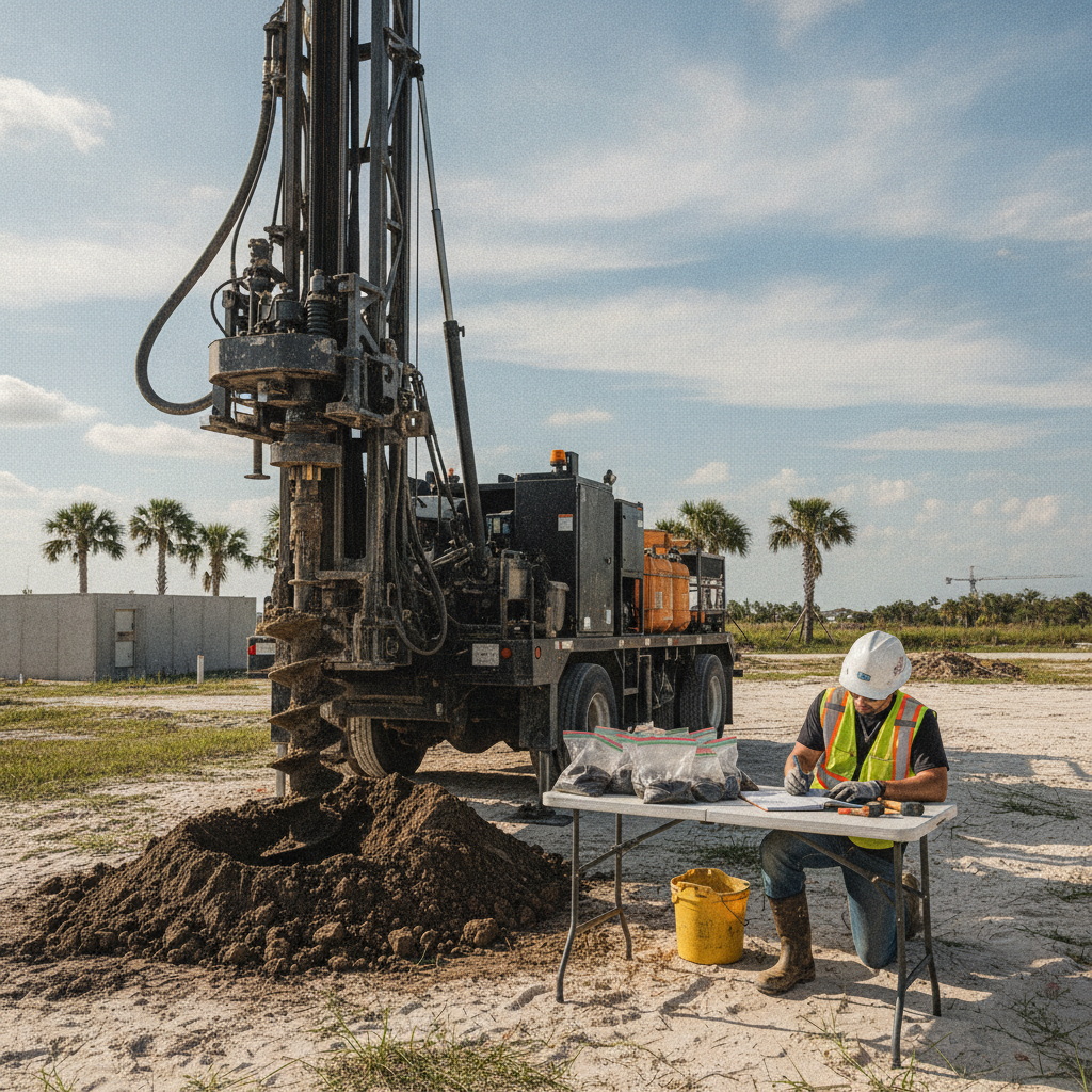
The core of the field investigation is the Soil boring test. A drilling rig is brought to the site to extract cylindrical soil samples at various depths. During this process, the driller often performs a Standard Penetration Test (SPT), which measures the soil’s relative density and provides a key metric (the ‘N-value’) used in engineering calculations. A field technician meticulously logs the recovered samples, noting changes in color, texture, and moisture, creating a detailed profile of the subsurface known as a boring log. Once collected, these samples are transported to a laboratory for a battery of tests. These tests quantify the soil’s physical properties, including moisture content, grain size distribution (sieve analysis), plasticity, and shear strength. For stormwater management design, permeability tests are crucial for determining exfiltration rates. This combination of field data and precise laboratory testing forms the empirical basis for the final Geotechnical soil report and its engineering recommendations.
Key Components of a Comprehensive Geotechnical Soil Report
The final Geotechnical soil report is a detailed document that synthesizes all field and laboratory findings into actionable guidance for the design team. It typically begins with an executive summary and a description of the project and site. The core of the report includes the finalized boring logs, which graphically represent the soil layers encountered in each boring, and a summary of the laboratory test results. These sections provide the raw data upon which the analysis is built. The most critical section contains the engineering recommendations. Here, the Geotechnical engineer provides specific guidance on foundation design, including allowable soil bearing pressures and estimated settlement. It will also include recommendations for pavement design (subgrade preparation and base course thickness), utility installation (excavation and backfill requirements), and the suitability of on-site soils for use as structural fill. This section is the bridge between the investigation and the actual civil engineering plans submitted for permitting.
How Geotechnical Data Influences Civil Engineering Design
The recommendations in the geotechnical report are not just suggestions; they are critical inputs that shape the entire site design. For stormwater management, the report’s data on soil permeability and groundwater levels dictates the feasibility and design of infiltration-based systems like exfiltration trenches and retention ponds. A low-permeability soil might necessitate a larger pond footprint or an underdrain system, directly impacting the site layout and available land for development. This is a key part of any drainage design. Similarly, utility coordination and design rely heavily on this data. The report specifies requirements for trench safety, dewatering, and the type of bedding and backfill material needed to support pipes and prevent settlement. For structural elements, the foundation recommendations are paramount. The report will guide the structural engineer in designing footings, slabs, and any required deep foundations (piles) to ensure long-term stability. Ignoring these recommendations can lead to failed inspections and significant liability.
Permitting Agency Requirements for Geotechnical Submittals
In Florida, a Geotechnical soil report is a required component of many permit submittals. The local municipality’s building department will require it to verify that the proposed foundation design is compliant with the Florida Building Code. They perform an agency review to ensure the structural plans are consistent with the geotechnical recommendations for bearing capacity and settlement. Furthermore, Florida’s Water Management Districts (WMDs) often require geotechnical information as part of an Environmental Resource Permit (ERP) application, especially for the design of stormwater ponds. They need to see data supporting the proposed pond’s ability to function as designed, including information on soil permeability and the seasonal high groundwater table to ensure proper water quality treatment and flood control. A deficient report can trigger review comments and delay the entire permitting process.
RSP Engineers’ Approach to Geotechnical Coordination and Review
At RSP Engineers, we view the geotechnical investigation as a collaborative process. While we are not a Geotechnical engineer firm, we provide essential site engineering services by managing the coordination with a qualified geotechnical partner. We help define the scope of the investigation, ensuring the number and location of borings are sufficient to characterize the site for the proposed development. This proactive approach helps avoid the need for costly additional testing later in the process. Once the draft Geotechnical soil report is available, our team of Civil Engineers conducts a thorough review. We integrate the recommendations directly into our site plan design, ensuring that the grading, drainage, utility, and paving plans are fully compliant. This integration is key to a streamlined agency review and helps prevent comments that could delay permitting. Our role is to translate the geotechnical data into a buildable, permittable, and cost-effective project.
Common Issues and Delays Related to Soil Investigations
Even with careful planning, subsurface investigations can uncover issues that impact project timelines and budgets. One of the most common problems is encountering unforeseen site conditions, such as buried construction debris, contaminated soils, or a much higher water table than anticipated. These discoveries can trigger significant construction delays and require redesigns or remediation efforts, often leading to costly change orders. Other issues can arise from an inadequate investigation. An insufficient number of borings might fail to identify a localized pocket of poor soil, which is only discovered during construction. In other cases, an agency review may deem the report insufficient for the project’s scale, forcing the developer to commission additional soil testing near me mid-permit, halting progress. Proper scoping and using an experienced Geotechnical engineer are the best ways to mitigate these risks.
Partner with RSP Engineers for Comprehensive Site Development
Navigating the complexities of subsurface conditions is a critical part of any successful Florida land development project. Misinterpreting a soil report or failing to integrate its findings can lead to significant delays and budget overruns. Our team at RSP Engineers provides expert site engineering services, including the critical review and integration of Geotechnical soil report data into your final construction plans. We ensure seamless utility coordination and a robust design that stands on a solid foundation. Contact us today to discuss your project’s geotechnical needs and ensure a smooth path through design and permitting.
Conclusion: Building on a Foundation of Data
In conclusion, a thorough geotechnical investigation is not merely a bureaucratic hurdle in the permitting process; it is a fundamental risk management tool and the bedrock of sound civil engineering design. The data derived from a Soil boring test and subsequent analysis informs critical decisions that impact project safety, budget, and schedule. By investing in a comprehensive Geotechnical soil report upfront, developers can avoid costly surprises during construction and deliver a final product that is safe, durable, and compliant with all Florida agency requirements.
FAQs
-
The number and depth of borings depend on the project’s size, the type of proposed structures, and the site’s known geological variability. A small commercial building might require 3-5 borings, while a large subdivision could require dozens. A Geotechnical engineer will propose a scope based on industry standards and the specific requirements of the Florida Building Code.
-
A Soil boring test uses a drill rig to obtain small, deep samples, providing a vertical profile of the soil. A test pit is a large excavation dug with a backhoe, allowing for a direct visual inspection of the near-surface soil strata (typically 10-15 feet deep). Test pits are useful for observing groundwater seepage and identifying bulky subsurface features but are limited in depth.
-
Generally, no. Agencies typically require a recent report that reflects the current site conditions and the specific proposed development. An old report may not account for changes in the groundwater table or may have been scoped for a different type of structure with different loading conditions. A new geotechnical investigation is almost always required for new permit submittals.